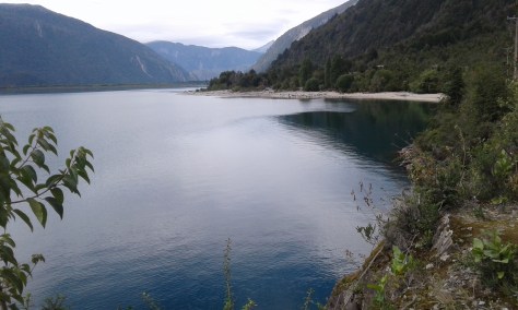
Tolhuin ist eigentlich ein unbedeutender Ort am Fagnano See, etwa 100 km vor Ushuaia. Aber es gibt zwei Einrichtungen, die ihn doch bemerkenswert machen:
Die Panadería Unión. Ein Treffpunkt für alle Traveller, die ans Ende der Welt unterwegs sind, mit gutem Internet, sehr guten Backwaren und ausgezeichneten Sandwiches. Außerdem thront hier eine Wachsfigur des berühmten Doktor Favoloro, einem Argentinier, der den „Bypass“ erfunden hat. Vielleicht hat der Besitzer der Panadería ja selbst einen Bypass und deswegen diesem Arzt hier ein Denkmal gesetzt:
Außerdem gibt es in Tolhuin einen besonders ausgefallenen Campingplatz. Hier findet ein Traveller alles außer WiFi. Roberto, der Besitzer erklärt, dass er kein WiFi will, damit seine Gäste persönlich miteinander kommunizieren und nicht in ihre Handys starren. – Darüber hinaus ist Roberto Künstler und hat seinen Campingplatz entsprechend mit seinen Müll-Kunstwerken ausgestattet.:
Es gefällt uns hier so gut, dass wir zwei Tage und drei Nächte verbringen, bevor wir endgültig nach Ushuaia aufbrechen.
JW/Clea
Español
Un lugar muy especial
En realidad Tolhuin, un pueblo situado a las orillas del Lago Fagnano, aproximadamente 100 kilómetros de Ushuaia, no es nada importante. Pero hay dos cosas, que lo hacen algo especial:
La Panadería Unión. Un sitio de encuentro para todos los viajeros, que están en ruta al „Fin del mundo“. Una panadería con un buen WiFi, mejores cosas dulces y unas empanadas y sándwiches espectaculares. Además hay una estatua de cera en un tipo de trono, que presenta al famoso doctor Favoloro, un argentino, que inventó el „bypass“. Es posible, que el propietario de la panadería quizás tenga un „bypass“ – no le preguntamos – y por eso a puesto este monumento en honor al doctor en la sala de su panadería.
Además hay un camping muy especial en Tolhuin. Acá el viajero encuentra todo lo que necesita menos una conexión WiFi. Roberto, el propietario, nos explica , que quiere que sus huéspedes se comuniquen entre sí y no estén mirando sus celulares todo el tiempo. – Roberto es un artista, que ha construido y decorado su camping exclusivamente con cosas, encontradas en la basura.
Nos gusta tanto este sitio que nos quedamos dos días y tres noches antes de empezar el último estrecho de nuestro viaje a Ushuaia.
JW/Clea
English
A very special place
Tolhuin is probably a place of little importance located at the Fagnano Lake, about 60 miles from Ushuaia. But there are two features, which make it special.
The Panadería Unión (The Union Bakery), which is a meeting point for all the travellers who are on their way to the „end oft he world“. A bakery with a good Internet connection, very good pastries and spectacular empanadas and sandwiches. In addition there is a wax figure on a kind of throne, which represents Doctor Favoloro, an Argentinian, who invented the bypass operation. Maybe the owner of the bakery has a bypass himself – we did not ask him – and therefore he set up this monument for th physician.
There is also a very special campground in Tolhuin. Ttravellers find everything they need on this place except for a WiFi connection. Roberto, the owner explains, that he wants his guests to communicate personally and not stare on their cellphones. – In addition Roberto is an artist who has set up the whole campground and decorated it with his art, which is exclusively made of things, he found in the garbage.
We like this place so much, that we stay two days and three nights her, before we finally set off for our final destination, Ushuaia.
Tierra del Fuego – Feuerland – ist eine Region in Südamerika. Ähnlich wie Patagonien gehört sie etwa zur Hälfte zu Chile und zu Argentinien. Sie liegt auf der Isla Grande del Fuego.
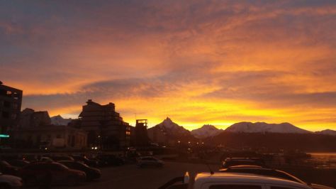
Ihren Namen hat die Insel von den vielen Feuern der Einheimischen, den Noam (link), die der Eroberer Magellan sah, als er sich der Insel näherte. Vielleicht waren es aber auch die unglaublichen Sonnenauf- und untergänge, die zu diesem Namen beigetragen haben:
Vom Festland gibt es zwei Fähren, mit denen man die Insel erreichen kann. Eine im Norden, die von Punta Delgada nach Bahía Azul führt und eine weiter südlich, die Punta Arenas und Porvenir miteinander verbindet. Diese Strecken entsprechen den jeweils kürzesten Verbindungen zwischen dem südamerikanischen Kontinent und der Insel Feuerland.
Wir überqueren die Magellanstraße im Norden:
Auf der anderen Seite machen wir zum ersten Mal Station in Cerro Sombrero in der Hostería Tunkelén. Cerro Sombrero war ursprünglich nur ein Camp für die Arbeiter der Ölindustrie. Die chilenische Regierung hat eine Reihe von städtischen Einrichtungen errichtet und allmählich erhält das Camp das Aussehen einer kleinen Stadt. Trotzdem ist der Ort, der offiziell Primavera (also „Frühling“) heißt, ziemlich isoliert trotz der Hostería Tukelén, in der die Arbeiter der Ölindustrie und Touristen auf dem Weg ans Ende der Welt einen sicheren Standplatz mit Stromanschluss und sanitären Einrichtungen finden; das Personal ist hilfsbereit und sehr freundlich:
Am nächsten Morgen fahren wir zu den Königspinguinen in der Nähe von Onaisin. Die Kolonie der Königspinguine hier bei Oniasin ist relativ klein. Ich bin ein wenig enttäuscht. Im Gegensatz zu den Magellan-Pinguinen, die u.a. in der Nähe von Punta Arenas ihre Kolonien haben, sind die Königspinguine auf Tierra del Fuego standorttreu und können das ganze Jahr beobachtet werden:
Auf dem weiteren Weg durch die einsame Landschaft begegnen wir immer wieder großen Schafherden, die vermutlich den Rest der Welt mit Wolle versorgen, geleitet von Gauchos auf Pferden (oder in 4×4 Pick-ups) und bewacht von einer Meute von Schäfer-Hunden:
Am letzten Tag im April geht es schließlich über die Grenze nach Argentinien. Nach den üblichen Einreiseformalitäten bei Einwanderungsbehörde und Zoll winkt uns der Beamte, der eigentlich unsere Esperanza inspizieren sollte, voller Vertrauen und mit einem freundlichen „Hasta la vista baby“ einfach durch, – ohne Inspektion! – Wir freuen uns über den lockeren und entspannten Empfang in Argentinien.
Viva Argentina!
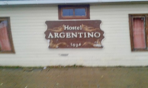
Leider macht das Wetter nicht mit. Auf der Strecke bis Rio Grande regnet es die meiste Zeit. Von der Landschaft sehen wir nicht viel, aber die Straße ist sehr gut und sicher und wir erreichen Rio Grande bei Einbruch der Dunkelheit. In der Hostería El Argentino finden wir einen Stellplatz im Hof, haben Stromanschluss und können die sanitären Einrichtungen nutzen. Besonders anheimelnd ist der Standplatz nicht, aber sicher und für eine Nacht o.k.
Am ersten Mai ist natürlich auch hier Feiertag. Bei dem schlechten Wetter kommt allerdings keine Feiertagsstimmung (link) auf. Um die Mittagszeit geht es weiter. Unser nächstes Ziel ist Tolhuin, vielleicht auch Ushuaia. Wir wissen noch nicht, wie weit wir heute kommen werden. Nach dem Besuch von Clemencias Geschwistern wollen wir uns irgendwo ein paar Tage erholen. (Link, 6 en un camello!)
Español
Tierra del Fuego es una región en América del Sur. Al igual que toda la Patagonia le pertenece la mitad a Chile, la otra a Argentina. Esta se encuentra en la Isla Grande del Fuego.
El nombre Tierra del Fuego responde a la observación de Magallanes, colonizador de esta zona quien divisó como primera señal el fuego hecho por los habitantes nativos de esta zona, los Noam. (Hier Link) Quizás el nombre también se debió a los fabulosos aterdeceres y amaneceres en esta isla.
Desde el continente hay dos ferrys con los que se puede llegar a la isla, Uno en el Norte, que va de Punta Delgada hasta Bahía Azul y otro más al Sur que va de Punta Arenas al Porvenir. Estos pasos han sido determinados por las distancias observadas como las más cortas entre la isla y el continente.
Pasamos el Estrecho de Magallanes por el Norte:
Al otro lado hacemos una estación en Cerro Sombrero en la Hostería Tunkelén. Cerro Sombrero es en realidad un campamento petrolero. El gobierno chileno ha dado facilidades para el asentamiento urbano y tienen una fecha para consolidarse como comunidad. Pore so el lugar es un poco solitario salvo la Hostería Tukelén que recibe a turistas, motocicleros de todo el mundo sobre todo en época de verano. Frente de la hostería podemos estacionarnos y usar todas las instalaciones del hotel. El personal es muy ayudador y simpático.
Al día siguiente nos dirigimos a los Pinguinos Reales cerca de Onaisin. La colonia de pinguinos es relativamente pequeña. A diferencia de los pinguinos magallánicos, que tienen sus colonias cerca de Punta Arenas son estos pinguinos sedentarios y pueden ser por tanto observados durante todo el año.
En el camino siguiente nos encontraremos con inmensas manadas de ovejas que seguramente proveen de lana a todo el mundo conducidas por Gauchos a caballo (o en pick ups 4 x 4 ) y claro, con una cantidad de perros pastores al lado.
En el último día de Abril pasamos finalmente la frontera con Argentina. Luego de todos los trámites burocráticos de migración un agente de aduana que debía revisar nuestra Esperanda nos deja pasar sin inspección y con toda confianz despidiéndonos con un ¨ hasta la vista baby! Nos gusta la forma argentina, más libres y relajada.
Viva Argentina!
Lamentablemente el clima en el trayecto a Rio Grande está feito… llueve casi todo el tiempo pero finalmente llegamos de noche hasta la Hostería El Argentino, donde encontramos un lugar para quedarnos.
Al día siguiente, como en todas parte del mundo, se celebra el 1ro. De mayo. No hay ambiente de fiesta con este día lluvioso. Nuestra siguiente parada será Tolhuin o Ushuaia. Luego de la visita de los hermanos de Clementina probablemente nos quedamos unos días para descansar. (Link, 8 en un camello!)
JW/Clea
English
Tierra de Fuego is a big region in South America. Like Patagonia one half belongs to Chile, the other half to Argentina. It is located on the Isla Grande de Tierra del Fuego.
Magellan, the European, who discovered the island, named it after he many fires of the natives, the Noam (link), which he saw on the island, when approaching it. Maybe the name has also got o do with the incredible sunrises and sunsettings on this island:
There are two ferries from the mainland tot he island. One in the North, which leaves from Punta Delgada and reaches the island at Bahía Azul, The other ferry, further down south, connects Punta Arenas with Porvenir. These routes represent the shortest possible connections between the continent and the Island of Tierra del Fuego.
We cross the Strait of Magellan in the North:
On the other side oft he strait we take our first stop in Cerro Sombrero. Originally Cerro Sombrero was aonly a camp fort he workers oft he petroleum industry. But the Chilean government has set up a number of urban facilities, which make the small place look like a little town. In spite of all the the efforts, Cerro Sombrero, which officially bears the name „primavera“ (which is „spring“ in Spanish,) is still a really isolated place. At least the Hostería Tunkelén provides a nice shelter to the workers of the petroleum industry and the tourists on their way to the end oft he world. In front of the Hostería Tukelén, we can park the car and stay overnight. It is a safe place and we can also use all the amenities of the hotel. The personnel is very friendly and helpful.
On the next morning we drive tot he colony oft he king penguins near Onaisin. It is a relatively small colony. I am a little bit disappointed. But in contrast to the Magellan Penguins, which have their colonies close to Punta Arenas, the king penguins stay in their colony all year round, while the others spend the winter time in warmer waters and can´t be seen in Tierra del Fuego.
On the way through the lonely countryside, we sometimes meet big herds of sheep, which probably provide hal the world which are guided and gauchos on horses and in 4×4 pick ups, and taken care off by groups of shepherd dogs, which take their jobs really serious.
On the last day of April we reach the border with Argentina. After the usual entrance formalities with immigrations and customs the agent, who is supposed to inspect our motorhome just waves us through with a friendly „Hasta la vista, baby“ on his lips. We are happy about the friendly and relaxed welcome to Argentina.
Viva Argentina!
Unfortunately the weather is bad. On the way to Rio Grande it is raining most oft he time. WE do not see much oft he landscape, but the road is very good and we reach Rio Grande before sun setting. In the Hosteria El Argentino we find a place to stay overnight, where we can connect our car with electricity and again you all the amenities of the simple hostel. For one night it´s ok..
Naturally May 1 is a public holiday in Argentina too. Unfortunately the weather is so bad, that there is no reason for holiday feelings. Around midday we continue our trip southwards. Our next destination is Tolhuín or maybe Ushuaia. We still don´t know, how far we will get today. After the visit of Clemencia´s family we want to spend a couple of quiet days somewhere.
Nach langen Diskussionen entschließen wir uns, alle zusammen in der Esperanza in den Parque Nacional de Torres zu fahren. Dort waren Clemencia und ich zwar schon, aber den Gletscher Grey haben wir noch nicht gesehen.
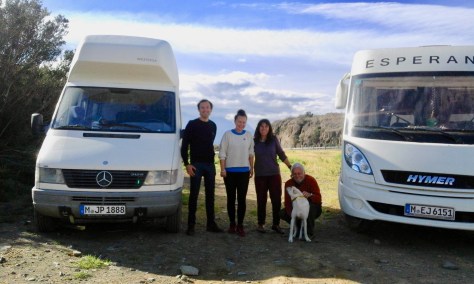
Zu fünft in unserem Wohnmobil ist es zwar ein bisschen eng, aber wir rücken zusammen und auf meinen ausdrücklichen Wunsch, nehmen unsere Gäste auch nur „kleines“ Gepäck mit. Wir selbst lassen ebenfalls einen großen Koffer in Punta Arenas im Hotel Carpa Manzano und so machen wir uns – immer noch deutlich überladen, aber guter Laune, auf die gemeinsame Reise. Es wird schon gutgehen:
Nach einer Übernachtung in Puerto Natales (link) geht es am nächsten morgen weiter bis Rio Serrano. Hier, am Rande des Nationalparks, finden wir das Hotel Lago Tyndall, das auch Cabañas hat und Hunde akzeptiert. Wir fühlen uns hier sehr wohl, obwohl wir fast die einzigen Gäste sind und das Wetter schon ziemlich winterlich ist. Am nächsten Morgen erleben wir einen besonders schönen Sonnenaufgang am Fluss:
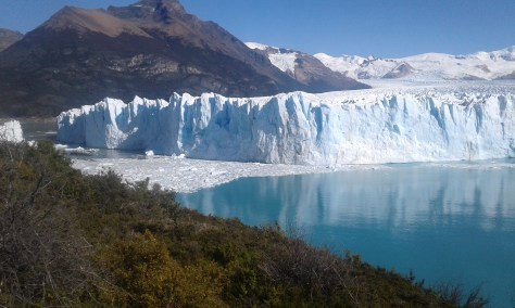
Hauptziel ist der Gletscher Grey. Ähnlich wie der Perito Moreno (link) ist er ein Touristenziel der besonderen Art. Man kann den Gletscher zu Fuß, im Rahmen einer mehrtägigen Trekkingtour oder mit einem Katamaran erreichen. Wir entscheiden uns natürlich für letzteres.
Aber bevor wir das Boot besteigen können, müssen wir erst einmal zur Anlegestelle. Die liegt in einer windgeschützten Bucht und ist etwa zwei Kilometer vom Parkplatz entfernt. Wir kommen spät zum Parkplatz und müssen uns mächtig anstrengen das Boot noch rechtzeitig zu erreichen:
Aber wir schaffen es und dann kann es losgehen. Trotz oder vielleicht auch wegen des schlechten Wetters ist schon die Anfahrt zum Gletscher sehr beeindruckend. Überall schwimmen Eisberge im See, die Felswände sind oft steil und abweisend, es bläst ein eiskalter Wind.
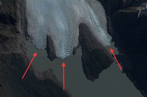
Und dann erreichen wir den Gletscher: Es gibt drei Teile, die bis an den See reichen und durch Felsformationen voneinander getrennt sind:
Die Eiswände sind nicht ganz so hoch wie beim Perito Moreno, doch insgesamt ist die Eisdecke um ein Vielfaches dicker als die des argentinischen Gletschers. Das liegt daran, dass die Abbruchkante des Perito Moreno praktisch auf dem Seeufer liegt, während sich der Grey Gletscher weit in den See hineinschiebt, bevor er abbricht. Sechs Siebtel der Eisschicht liegen daher unter Wasser:
Das dritte Abschnitt des Grey-Gletschers ist wegen seiner unterschiedlichen Blautöne besonders ungewöhnlich und – ja man kann das durchaus sagen – märchenhaft. Wir stehen einfach an der Reling und staunen, während das Boot fast lautlos an den Eiswänden vorbeigleitet:
Gelegentlich wird diese Stille aber durch einen Höllenlärm und ein unglaubliches Spektakel unterbrochen:
Um das zu erleben, muss man aber viel Glück haben oder monatelang warten wie die Kameraleute dieses BBC-Films über Patagonien, den es auch auf Youtube zu bewundern gibt (link).
JW/Clea
Español
Camino al glaciar Grey
Después de algunas discusiones decidimos ir todos juntos con Esperanza al Parque Nacional Torres del Paine. Un lugar que Clementina y yo ya conocíamos … sin embargo el glaciar Grey no lo habíamos visto aún.
Cinco en nuestra casa rodante es un poco estrecho, pero todos nos movimos para un lado y les rogamos a nuestros huéspedes de llevar solamente un pequeño equipaje. Nosotros mismos dejamos también una maleta en el Hotel Carpa Manzano en Punta Arenas y nos enrumbamos a un viaje en conjunto con buen ánimo y contentos. Va a salir todo bien.
Después de una noche en Puerto Natales seguimos al día siguiente hasta el Rio Serrano. Aquí al borde del parque nacional encontramos el Hotel Tyndall con cabañas que aceptaban también perritos. Nos sentimos muy bien a pesar de ser uno de los últimos huéspedes de temporada y el clima ya se siente bastante invernal. A la mañana siguiente experimentamos un amanecer impresionante en el río.
Nuestra meta final era el glaciar Grey. Al igual que el de Perito Moreno (link) resulta éste un elemento de atracción turística de especial connotación. Se puede llegar muy cerca del glaciar y llegar a él en un trekking a él o con un catamarán. Decidimos naturalmente por la segunda opción.
Antes de abordar el catamarán tenemos que caminar hasta el punto de despegue. Está en una bahía protegida del viento a unos dos kilómetros del estacionamiento. Hay poco tiempo y tenemos que esforzarnos para alcanzar el bote
Pero lo logramos antes que partiera. A pesar del mal tiempo o quizás por el mal tiempo resulta ya la partida muy impresionante. Por todos lados nadan piezas del glazial en tonos azules. Hay un viento helado:
Y ahí alcanzamos el glaciar. Hay tres caras que llegan hasta el lago y que se separan entre si por diferentes formas de rocas.
Las paredes de hielo no son tan altas como las de Perito Moreno, pero en general resulta la pared de hielo más gruesa que la del glaciar argentino. Esto se debe a que el lado de ruptura del Perito Moreno está practicamente en la orilla del lago, mientras que el glaciar Grey se empuja hacia el fondo del lago antes de romperse. Las seis setimas partes del glaciar Grey se encuentran bajo el agua:
El tercer corte del glaciar Grey es realmente fuera de serie por sus tonos azules , si realmente podemos decir son de cuento. Estamos asombrados en silencio observando estas paredes de hielo:
Pero de vez en cuando se rompe este silencio por un ruido infernal y un espectáculo increíble.:
Para experimentar esto hay que tener mucha suerte o esperar meses como los operadores de cámara de este documental de la BBC sobre Patagonia, que también se puede ver en youtube.
JW/Clea
English
To the Glacier Grey
After long discussions we decide to go together to the Parque Nacional de Torres in our Esperanza. Clemen and I have already been there (link), but we have not yet seen the glacier Grey.
With five of us it is a little tight in our motorhome, but we move a litttle closer together and following my explicit request our guests only take light baggage with them. WE also leave a big suitcase in the Hotel Carpa Manzano in Punta Arenas and so we start our common trip – still obviously overloaded – but in a cheerful mood. Everything will be all right, we hope:
After a stop over in Puerto Natales (link) we go on to Rio Serrano the next morning. Here, at the entrance to the National Park we find the Hotel Tyndall, which also offers cabins for rent and is pet-friendly. We like this place very much, even though we are almost the only guests and the weather is already quite winterly. On the next morning we have a wonderful sunrise at the river:
Our main destination is the Glacier Grey. Like the Perito Moreno (link) in ARgentina it is a main attraction for tourists. One can take a several day trekking tour to the glacier or get there by catamaran. We decide on doing the latter.
But before we can board the boat, we have to walk to the place, from where it is leaving. This place is a wind protected bay about 1.3 miles from where we have to leave our motorhome. We have reached the parking lot late and have to exert ourselves to get to the boat on time:
But we make it on time and the trip can start immediately. In spite of or maybe because of the bad weather the trip to the glacier is already very impressive. Everywhere there are icebergs floating on the lake, the black mountain walls a very steep and repelling. An icy wind is blowing.
And then we get to the glacier. It has three faces, which reach to the lake and are divided by solid, big rock formations:
The ice walls oft he glacier are not quite as high as the face of the Perito Moreno glacier, but the ice layer of the glacier Grey is several times thicker than that of the Argentine glacier. This is due to the fact, that the face of the Perito Moreno glacier practically sits on the banks of the lake, while the Glacier Grey reaches far into the waters of the lake, before the ice bergs brake off. Six out of seven parts of the ice layer are submersed in the water:
The third part of the glacier is very special because of the many blue hues of the ice and it is not an exaggeration to say that this is like in a fairy tale. We simply stay at the rails and feel awe and wonder, while the boat is almost silently gliding along the blue ice world.
But some times the tranquility of this place is explosively interrupted by a hellish noise and incredible spectacle:
But in order to experiment something like that you have to have great luck or wait for months like the cameramen of this BBC documentary about Patagonia, which you can also watch on YouTube.
Punta Arenas ist eine Großstadt am Südende des amerikanischen Kontinents. Früher war es nur eine einfache Hafenstadt. Von den alten Zeiten erzählen noch einige Wandmalereien an der Küstenstraße:
In dieser abgelegenen Gegend der Erde sind die Menschen sehr geschichtsbewusst. Davon zeugen verschiedene Monumente, die an die Besiedelung der Region und die Gefahren und Gebräuche dieser Zeit erinnern:
Heute ist Punta Arenas eine moderne Großstadt, mit verkehrsberuhigter Zone, mit einer schönen zentralen Plaza, mit guten Restaurants und einigen repräsentativen Hotels:
Seinen Aufstieg hat Punta Arenas vor allem dem Tourismus und der wachsenden Bedeutung der Antarktis zu verdanken. Von hier aus kann man den Nationalpark Torres del Paine besuchen oder auch eine Kreuzfahrt in die Antarktis machen. In Punta Arenas starten auch all die Abenteurer, die nach Ushuaia in Feuerland unterwegs sind, all die Camper, Motorrad- und Fahrradfahrer und Rucksacktouristen, die – wie wir – die Luft der ersten Pioniere atmen wollen, die noch immer diese Gegend durchdringt.
Bei den „Torres“ waren wir schon (link), unsere Fahrt nach Ushuaia (Link) beginnt nächste Woche und das mit der Antarktis müssen wir in Ushuaia entscheiden. Inzwischen haben wir allerdings gelesen, dass in Feuerland Schnee angesagt ist.
Aber auch in der Nähe von Punta Arenas, gibt es Natur pur, z.B. bei einem Ausflug bis zur Südspitze des Kontinents (link). Jenseits davon, – nur noch Meer…
JW/Clea
Español
Donde Chile (casi) termina
Punta Arenas es una ciudad grande al Sur del continente americano. Antes fue una simple ciudad portuaria. De ese tiempo antiguo cuentan algunos murales en la costanera de la ciudad
En esta parte apartada de la tierra viven los hombres muy conscientes de su historia. Sobre esto hablan los distintos monumentos que ilustran la colonización de esta zona agreste así como de los peligros y costumbres de esta zona
Hoy es Punta Arenas una ciudad grande y moderna con un tráfico y un paseo peatonal, una plaza central buenos restaurantes y hoteles muy representativos.
Su importancia la adquiere Punta Arenas sobre todo por el turismo y la creciente importancia de la Antártida. Desde aquí se puede visitar el Parque Nacional Torres del Paine o hacer un crucero al la Antártida. Desde Punta Arenas parten también todos los aventureros que están en camino a Ushuaia en Tierra del Fuego, los camperos, motociclistas, ciclistas y mochileros, que – como nosotros – quieren respirar este aire puro de los primeros pioneros que aún se respira en esta zona.
Estuvimos ya donde „las torres” (link). Nuestro camino a Ushuaia (link) comienza la semana que corre y con respecto a la Antártida lo decidiremos en Ushuaia mismo. Mientras tanto hemos escuchado que ha nevado en partes de Tierra del Fuego!
Pero cerca de Punta Arenas también hay pura naturaleza, por ejemplo en una excursión hacia la punta más al sur del continente Americano (link). Más allá … puro mar…
JW/Clea
English
Where Chile has (almost) reached its end
Punta Arenas is a big city at the southern end of the American continent. In former times it was only a simple port. Some wall paintings along the beach boulevard tell about the old times:
In this remote area oft he world the people are much aware of their history. Lots of monuments remind the visitor of the times of the early settlerment with all its dangers and customs:
Today Punta Arenas is a modern city with a pedestrian mall, a beautiful central plaza, with some good restaurants and representative hotels.
Its recent economic upswing Punta Arenas mainly owes to tourism and the growing importance of the Antarctic. From here you can visit the National Park of the Torres del Paine or a take a cruise to the Antarctic. Punta Arenas is also the place, from where all the campers, bikers, cyclists and backpackers like us, who want to breathe the air of the early pioneers, which you can still feel everywhere in this region, start their trip to Tierra del Fuego (link), the big island south oft he continent, which belongs to Chile and Argentina.
The „Torres“ we have already visited (link), lo de Tierra del Fuego we will do next week (link), and the cruise to the Antarctica, – well, we still don’t know, we will decide in Ushuaia. But even close to Punta Arenas one can get a deep impression of what nature is like in this area, for example on an excursion to the southern tip of the South American continent (link).
Etwa 70 km südlich von Punta Arenas liegt der Leuchtturm San Isidro. Die Straße in den Süden endet etwa 4 km vor dem Leuchtturm. Den Rest muss man zu Fuß gehen über den Strand. – Das Besondere an dieser Wanderung: Hier reicht der weitgehend unberührte Urwald bis direkt an den zerklüfteten Strand:
Vom Leuchtturm zur geographischen Südspitze der Kontinents sind es dann noch knapp 30 km. Unterwegs gibt es zwei Plätze, wo man campieren kann. Shanti und ich sind uns einig: Das machen wir das nächste Mal.
JW
Español
Aproximadamente 70 kilómetros en el sur de Punta Arenas se encuentra el Faro de San Isidro. La carretera hacia el sur termina unos 4 kilómetros antes del faro. El resto tienes que caminar por la playa. – Es una caminata muy especial: Acá la selva llega hasta la playa escarpada.
Desde el faro hasta el punto más al sur del continente hay casi unos 30 kilómetros más. Hay dos campings sencillos en el camino. Shanti y yo estamos de acuerdo: Este vamos a hacer la próxima vez.
JW
English
About 70 kilometers south of Punta Arenas there is the lighthouse San Isidro. The road to this area ends about 4 kilometers before the lighthouse. The rest you have to walk on the beach. – It is a very special walk: Here the pristine woods meet the rocky beach.
From the lighthouse it is another almost 30 kilometers to the southernmost point of the continent. There are too simple campgrounds on the way. Shanti and I agree: This is something we will do next time.
Westlich von El Calafate, im Süden von Patagonien in Argentinien, liegt der Gletscher Perito Moreno. Er hat seinen Namen von Francisco Pascasio Moreno, einem argentinischen Naturforscher. Nach ihm sind eine Stadt, ein Nationalpark und dieser Gletscher benannt. Obwohl Perito Moreno große Teile Patagoniens in Argentinien erschlossen und erforscht hat, hat er nie den nach ihm benannten Gletscher gesehen. – Er wäre begeistert gewesen.
Der Perito Moreno bietet eines der schönsten Naturschauspiele in Südamerika:
JW/Clea
Español
Al este de El Calafate, al Sur de la Patagonia argentina se ubica el glaciar Perito Moreno. El glaciar lleva el nombre de Francisco Pascasio Moreno (Link), un investigador argentino. En honor a él hay una ciudad, un parque nacional y el glaciar y todos llevan su nombre. Perito Moreno quien investigó y contribuyo a configurar la Patagonia argentina nunca alcanzó a ver el hermoso glaciar.
El Glaciar Perito Moreno ofrece uno de los escenarios naturales más hermosos de América del Sur:
JW/Clea
English
West of El Calfate in the south of the Argentinian Patagonia there is the Perito Moreno Glacier. It is named after Francisco Pascasio Moreno (Link) an Argentine scientist and explorer. A city, a National Park and this glacier carry his name. Even though Perito Moreno has discovered and studied big parts of Patagonia, he has never seen the glacier, which is named after him. – He would have been enthusiastic.
The Perito Moreno is one oft he most beautiful natural sights in South America:
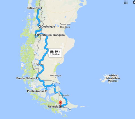
wie Ihr auf der Startseite sehen könnt, sind wir in El Calafate, bereits ziemlich weit im Süden von Patagonien. Von Ushuaia, dem südlichsten Ziel aller Panamericanafahrer, trennen uns nach über 42000 km Reisestrecke und 14 Ländern, die wir bereits durchquert haben, noch ungefähr 1000 km.
Wie schon seit längerer Zeit, können wir unseren Blog nur sehr sporadisch auf den neuesten Stand bringen. In den Orten, die wir ansteuern, gibt es zwar meistens Internet, aber das ist langsam und die Upload-Zeiten sind unendlich.
Wir hoffen nun darauf, dass es in Chile (in Puerto Natales oder in Punta Arenas) wieder besser wird und wir einiges hochladen können, vor allem auch die schönen Bilder und Videos von Patagonien. Hier schon einmal ein kleiner Vorgeschmack:
Bitte habt Geduld mit uns, wir geben uns alle Mühe, Euch auf dem Laufenden zu halten. Wirklich aktuell können wir aber leider nicht sein. Alles dauert seine Zeit – und hierzulande noch ein bisschen mehr:
Liebe Grüße
JW/Clea
Español
Queridos amigos en todo el mundo,
Como pueden ver en nuestra página inicial hemos llegado a El Calafate, Argentina, bastante bien al Sur ya de la Patagonia. Después de haber recorrido más de
42000 y visitado 14 países, nos separan de Ushuaia (Argentina), punto final de los viajeros de la Panamericana, escasamente 1000 Km más.
Desde ya hace tiempo podemos actualizar nuestro blog muy esporádicamente. A los lugares en que llefgamos hay para nuestra sorpresa Internet, pero es muy lento y no nos permite subir videos de las maravillas que estamos viendo y queremos compartir con ustedes.
Esperamos que en Chile sea en Puerto Natales o Punta arenas mejore la cosa y podamos subir algunos vídeos, sobre todo los hermosos vídeos y fotos de La Patagonia. Aquí un aperitivo pequeñito.
Por favor ténganos un poquito de paciencia!… Tratamos de dar lo mejor de nosotros para mantenerlos al tanto. Actualizados realmente no podemos estar. Ahora conocen nuestras razones. Todo toma su tiemo y por estos lares, un poquito más aún.
Saludos cariñosos
JW/Clea
English
Dear friends all over the world,
As you can see on our start page we have reached El Calafate (Argentina), which is already far south in Argentina. Even though we have already travelled over 26,000 miles and crossed 14 countries, there are still about 600 miles, which separate us from Ushuaia, which is the most southern destination of all those who travel the Panamericana.
For quite some time we have not been able to administer our blog well and could only sporadically upload new posts. In many places, where we go, they do have internet, but it is very slow and the upload times are endless.
We hope that it will be better in Chile (in Puerto Natales or in Punta Arenas) and that we will be able to upload some of the videos and pictures, which we have already prepared, especially those about wonderful Patagonia. Here are a few teasers:
Please be patient with us, we are trying our best in order to keep you informed about our trip. Unfortunately we cannot be up-to-date. Everything takes quite some time here – and sometimes even more.
Nach der Achterbahnfahrt von gestern, geht es heute zur „Cueva de las Manos“. Eigentlich sind es keine richtigen Höhlen, sondern riesige Felsnischen und Felsabbrüche, in denen es zahlreiche Bilder mit Händen, Tieren und einigen wenigen Menschen gibt. Die ältesten Bilder sind über 9000 Jahre alt. Die meisten sind aufgesprühte Negativbilder von Händen. Wer nachzählt findet etwa 830 Hände an den Wänden, die große Mehrheit von Rechtshändern:
Die „Cuevas de las Manos“ finden sich in einem beeindruckenden Cañon, durch den der Rio Pinturas fließt. Es ist dieselbe Schlucht, die wir gestern nur mit größter Mühe durchqueren konnten:
Gegen Abend beschließen wir, noch eine Nacht an unserem exponierten Standplatz zu verbringen und ein Feuer zu machen. Da es tagsüber relativ viel geregnet hat, ist es schwierig, das feuchte Holz in Brand zu setzen, – aber nach einiger Zeit, mit viel Geschick von Beñat und der fachkundigen Mithilfe von Shanti, gelingt es schließlich doch, etwas Wärme in die abweisend kühle und feuchte Landschaft zu zaubern.
JW/Clea
Español
La Cueva de las Manos
Después de la Montaña Rusa de ayer nos fuimos a las ¨Cuevas de las Manos: . En realidad no son cuevas sino muros de piedras delante de las cuevas donde se pueden apreciar cantidades de manos, animales y figuras diferentes estampadas para la eternidad. Las más antiguas tienen más de 9 000 años de antigüedad. La mayoría están ahí por un método de soplado del color colocando la mano como muestra. Quien las cuenta encontrará más de 830 manos en las paredes, la mayoría de las manos derechas
Esta ¨Cueva de las Manos¨ se encuentra en un cañón impresionante donde corre el Rio Pinturas. Es el mismo cañón por el cual pasamos ayer con dificultad (link).
Por la noche dormimos una vez más en nuestro lugar un tanto expuesto e hicimos un fuego. Como había llovido bastante durante el día parecía difícil lograr un fuego con las maderas mojadas . El empeño de Breñat, Clementina y Shanti como colaborador lograron el fuego aportando calor al paisaje frío y húmedo como por arte de magia.
JW/Clea
English
Las Cuevas de las Manos / The Cave of the Hands
After yesterday’s roller-coaster drive we are going to visit the „Cave oft he Hands“ today. It is not a real cave, but some huge niches in the rocks, where there are a lot of paintings of human hands, animals and some human figures. The oldest pictures are over 9000 years old. Most of them are negative pictures, which were sprayed on the walls around the hands. Those who want to count them, will find approximately 830 hands, most of them of right handers.
The Cueva de las Manos is located in the impressive canyon of the river Pinturas. It is the same abyss, which we could hardly cross yesterday.
Towards evening we decide to stay another night at the exposed place near the gorge, where we already spent the first night. But this time we want to have a big fire. Since it has rained a lot most of the day, it seems to be difficult to set the wet wood, which we find in the area afire. – But after some time with Beñat’s knowledgeable help and the support of Shanti, we finally manage to have a really nice fire, which helps us to warm up a little bit the cool and moist atmosphere of the whole landscape.
Auf dem Weg zu „La Cueva de las Manos“, etwa 30 km östlich der Ruta 40, nehmen wir aus Versehen eine Abkürzung. Am Anfang geht alles wunderbar: Die Straße ist zwar unbefestigt, aber breit und hat relativ wenig „Wellblech“. Da haben wir auf der Carretera Austral in Chile viel schwierigere Pisten erlebt. Was wir nicht wissen: Etwa auf halber Strecke, gibt es eine tiefe Schlucht, die wir passieren müssen. Vor uns liegen plötzlich extreme steile Abfahrten, vor denen zwar gewarnt wird, aber leider ohne Hinweis, dass man hier eigentlich 4 x 4 Antrieb braucht, um wieder herauszukommen. Runter geht es noch einigermaßen mit unserer Motorbremse, aber wir denken natürlich auch an den Rückweg. Ob Esperanza das schafft???
Sie schafft es nicht! Wir kommen noch nicht einmal auf der anderen Seite wieder raus aus dem Canyon. Die Piste ist extrem steil und geschottert. Schon nach gut hundert Metern bergauf ist Schluss und die Vorderreifen drehen durch. Ich lasse das Auto sehr langsam und vorsichtig zurückrollen.
Unten steht ein PKW mit Norwegern, die uns erklären, dass es zu den Cuevas ziemlich weit so steil bergauf geht. Ganz oben sei es dann aber besser, dort komme man dann auch zu der Hauptstrecke, die eigentlich flach sei. – Uns wird bewusst, dass wir die falsche Route genommen haben und in der Falle sitzen.
Wir versuchen es noch einmal, aber auch der zweite Versuch misslingt. Zurück geht es auch nicht, denn zumindest dem Augenschein nach ist die Steigung auf der Seite, die wir heruntergekommen sind, noch steiler als in Richtung der Höhlen und der Hauptstraße.
Uns bleibt nur eins: Entweder einen Abschleppwagen organisieren oder es im Rückwärtsgang versuchen. Wir entscheiden uns für die Fahrt im Rückwärtsgang und – ja, es ist eine nervenaufreibende Fahrt, aber die Hinterräder drehen nicht durch und langsam und mit einigem Bangen, mit Schwanken und Schwänzeln des Hinterteils, an der Grenze der Leistungsfähigkeit unseres Motors, der kurz vor dem Absterben ist und mit zwei Wagen, die uns bergab entgegen kommen, unsere Verzweiflungsaktion aber Gott sei Dank rechtzeitig erkennen und ausweichen, schaffen wir die ca. 5 Kilometer bergauf im Rückwärtsgang.
Leider gibt es von dieser Achterbahnfahrt im Rückwärtsgang keine Aufnahmen, da niemand die Nerven oder die Zeit hat, das alles auch noch zu filmen. Clemencia nicht, die sich mit Shanti nach hinten im Auto verzogen hat und Bertran auch nicht, den wir auf dieser Strecke als Anhalter mitgenommen haben. Er hilft mir stattdessen bei dem schwierigen Manövrieren des Autos auf der kurvenreichen Strecke, auf der ich natürlich nicht stehen bleiben kann.
Nachdem wir schließlich am Ziel angekommen sind, bleiben wir auf einem Plateau etwas oberhalb der Höhlen stehen und richten uns für die Nacht ein. Wir sind alle ziemlich fertig, Shanty muss sich übergeben. Aber natürlich sind wir glücklich, dass Esperanza es trotz allem wieder einmal geschafft hat:
JW/Clea
Español
En la trampa
En el camino a “La Cueva de las Manos¨ unos 30 Km al este de la Ruta Nacional 40, tomamos por equivocación un desvío. Al principio la carretera era de ripio pero manejable. En la Carretera Austral de Chile hemos tenido pistas más difíciles. Lo que no sabíamos es que a la mitad del camino entramos como a un abismo profundo, por el cual teníamos que pasar. Delante de nosotros habían bajadas muy empinadas que están señalizadas y avisan al público con esto, pero faltaba la indicación que tenía que ser mejor el uso de un 4 x 4 para poder salir.
Hacia abajo pasamos fácilmente con nuestros frenos de motor, pero pensábamos ya como sería el retorno para salir … si nuestra Esperanza lo logrará?
Y NO pudo. Ni para atrás ni para adelante. Estábamos en una trampa. La pista es extremadamente empinada, ripio. Menos de 100 metros y las ruedas delanteras rodaban… Juergen deja el auto resbalar con cuidado hacia abajo.
Abajo hay un auto de unos noruegos – familia joven con dos niños – que nos dicen que hacia las cuevas los caminos son muy empinados. Una vez arriba es mejor y ahí se empalma con la ruta principal que es bastante plana. Ahí nos dimos cuenta que habíamos tomado la ruta equivocada y que estábamos en una trampa.
Lo intentamos una segunda vez … sin suerte. Para atrás tampoco podemos porque lo acabamos de bajar es más empinado aún que lo que tenemos por delante.
Nos quedaba solo una opción: o llamar una grúa o intentarlo en marcha atrás. Nos decidimos por la marcha atrás. Es una opción que nos paraba los pelos de punta pero observamos que las ruedas traseras no patinan y despacio limitando a los límites de nuestro motor que pareciera próximo a fallecer y con dos autos que venían en dirección contraria que reconocieron nuestra dificultad dejándonos el campo libre de tal manera que logramos los ca. 5 kilómetros hacia arriba en marcha atrás.
Lamentablemente no tenemos tomas de esta Montaña Rusa en marcha atrás ya que nadie tuvo el tiempo ni los nervios de filmar. Clementina ni hablar, quien se fue para atrás con Shanty. Tampoco Bertran, mochilero que recogimos en el camino. El me ayudó en estas maniobras difíciles con el auto en una carretera empinada y llena de curvas, donde claro era imposible parar.
Después de llegar a nuestra meta en la meseta casi arriba de las cuevas nos preparamos para la noche. Shanty vomitó. Todos estamos deshechos y muertos de cansancio. Agradecidos y felices que Esperanza lo logró una vez más.
JW/Clea
English
Being trapped
On the way to the „Cueva de las Manos“, about 18 miles east of the RN 40, we take a deviation by mistake. At the beginning everything looks fine: The road is not tarmacked, but it is wide and not very corrugated. On the Carretera Austral in Chile we had to travel roads much worse than this one. What we do not know: About half the way to the caves, there is a deep abyss, which we have to go through. All of a sudden there are very steep downhill parts, which are well sign posted, but not marked as 4 x 4 tracks only. Downhill we still make it without real problems and the help of our engine brake, but we start thinking, how the hell we will get back on this road. Will Esperanza be able to make it?
She is not able to do it. We cannot climb up on the other side of the canyon. The track is extremely steep. After the first about 100 meters uphill our front wheels loos grip. I have to let the car idle backwards very slowly and carefully.
At the bottom of the gorge, there is a car with a family from Norway. They tell us, that the track will continue like that pretty far. But after that it will reach the main road, which is plain and easy. – We are getting aware of the fact, that we have taken the wrong way and are trapped.
We try it again, but the second try is not successful either. And we do not even try to go back, from where we come, because the road seems to be even steeper than where we are heading.
We only have one choice: To try and get help from a towing service somewhere in the middle of nowhere or try the ascent in the reverse. – We decide on trying the reverse option and – yes it is a nerve breaking drive, but the back wheels do not lose their grip and with some swaying of our rear part, with bouncing from one side of the road to the other, with great tension inside the car, the engine at the edge of its power and two cars coming down the road – fortunately with drivers who immediately understand our emergency maneuvering and move to the other side of the road so that I do not have to stop – we finally get up approximately 5 kilometers in the revers, before we reach flatter terrain.
Unfortunately there are no takes of photos of this roller-coaster drive, because nobody had the nerves to grab a camera. Clemencia had disappeared with Shanti on the rear bench of Esperanza and Bertran, the hitchhiker who we had offered this lift to the caves, was helping me with the difficult navigation of the car through the many curves uphill and in the reverse without even thinking of stopping the car at any moment.
After we have finally reached our destination, we stay on a plateau above the caves and settle down for the night. We are all done. Shanty even has to throw up. But we are also very happy that Esperanza has made it one more time.
Patagonien ist viel, viel größer als alle Regionen, die wir bisher bereist haben.
Hier zwischen Coyhaique und O’Higgins in der Region Aysén liegt das Campo Hielo del Norte. In diesem Gebiet befindet sich auch der Nationalpark Laguna San Rafael.
Weiter im Süden liegt das Campo Hielo del Sur.
Durch den Campo de Hielo del Sur in Chile kann man nur auf Schiffen oder Fähren durch die Fjorde Patagoniens bis nach Puerto Natales oder Punta Arenas gelangen.
Wer mit dem Auto unterwegs ist, muss über die Ruta Nacional 40 (link folgt) in Argentinien fahren, um weiter in den Süden und später wieder nach Chile zu gelangen:
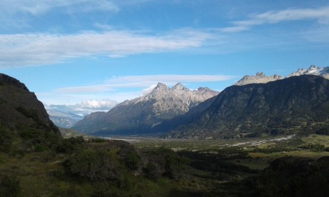
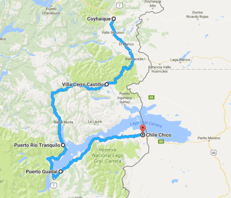
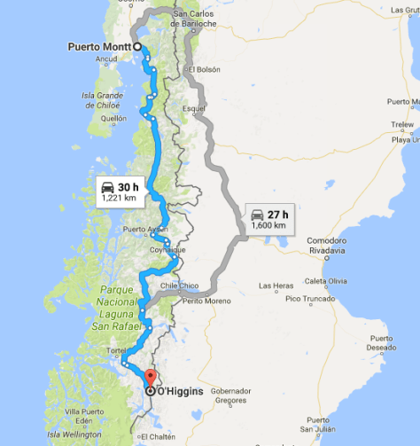
Insgesamt trennen uns jetzt noch rund 2.500 km von Ushuaia. Für die nächsten Tage haben wir uns vorgenommen, über Cerro Castillo nach Puerto Tranquilo und von dort nach Chile Chico an der Grenze zu Argentinien zu fahren.
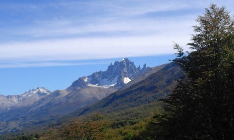
Die erste Übernachtung legen wir kurz hinter Villa Cerro Castilla ein. Auf einem Teilstück der alten Carretera Central mache wir Station und treffen dort auch ein Paar aus München, die in der anderen Richtung unterwegs sind.
Gegen Abend genießen wir die Ruhe und den Ausblick auf die nahe gelegenen Andengipfel.
Am nächsten Tag geht es weiter nach Puerto Rio Tranquilo:
Der Ort ist wirklich so ruhig wie sein Name sagt:
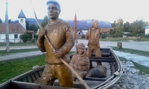
Ein hölzernes Monument macht auf die ersten Siedler aufmerksam, die vermutlich auch von der Fischerei lebten:
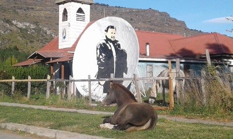
Es ist so ruhig hier, dass ein Pferd ein bequemes Plätzchen vor der Kapelle gefunden hat:
Heute ist es in erster Linie der Tourismus, der Puerto Rio Tranquilo am Leben erhält. Hauptsächlich sind es junge Leute, die von hier aus zu langen Trekking Touren aufbrechen.
Wir stehen mit unserer Esperanza am Ufer des Lago General Carrera und selbst Shanti weiß nach ein paar Tagen nicht mehr so recht, was er hier soll – trotz des schönen Ausblicks auf See und Berge:
Wirklich beeindruckend und einmalig ist die Bootsfahrt zur nahe gelegenen Marmorkathedrale.
Danach geht es weiter bis Chile Chico an der Grenze zu Argentinien. Das sind nur noch 170 Kilometer, aber die Straße ist nicht geteert, auf der östlichen Seite des Sees teilweise einspurig und immer wieder sehr steil. Wieder einmal eine ziemliche Anstrengung für Esperanza und uns:
JW/Clea
Español
Cerca del Campo de Hielo Norte
La Patagonia es la región más amplia que hemos visitados hasta ahora.
Aquí entre Coyhaique y O’Higgins en la región de Aysén se encuentra el Campo Hielo del Norte. En este lugar se encuentra el Parque Nacional Laguna San Rafael.
Más hacia el Sur está el Campo de Hielo del Sur.
Por el Campo de Hielo del Sur en Chile se puede llegar solamente en barco o ferrys a través de los fiordos de Patagonia hasta Puerto Natales o Punta Arenas.
Quien está con el auto por ahí tiene que tomar la Ruta Nacional 40 (link folgt) en Argentina y continuar luego por el Sur para entrar nuevamente en Chile.
En total nos faltan aún 2500 km hasta Ushuaia. En los siguientes días nos hemos propuesto llegar a Chile Chico en la Frontera con Argentina. pasando por Cerro Castillo a Puerto Tranquilo y de ahí a Chile Chico.
La primera noche la casamos en Cerro Castillo. En una parte de la antigua Carretera Austral haceos un alto y ahí nos encontramos con una pareja de Múnich que va en dirección contraria a nosotros.
Por la noche disfrutamos de la tranquilidad y el panorama a los Andes cercanos.
Al día siguiente continuamos hacia Puerto Rio Tranquilo.
El Lugar es realmente tan tranquilo como su nombre lo dice.
Un monumento en madera que nos remonta a la época en que los primeros pobladores de la zona vivían de la pesca.
Es tan tranquilo acá que un caballo ha encontrado un lugar cómodo frente a la capilla.
Hoy en día Puerto Tranquilo vive más que nada del turismo. Generalmente es gente joven que emprende desde acá caminatas largas.
Estamos parados con nuestra Esperanza a la orilla del Lago General Carrera y el mismo Shanty no sabe qué hacer luego de un par de días, a pesar del encanto de lago y montañas.
Realmente impresionante resultó para nosotros el paseo hacia la Catedral de Mármol. (link).
De ahí seguimos hacia Chile Chico en la frontera con Argentina. Son solamente 170 Km pero la carretera no está asfaltada, en la parte este del lago, en una sola vía y con muchas subidas empinadas y luego bajadas. Gran esfuerzo para nuestra Esperanza su tripulación.
JW/Clea
English
At the Northern Ice Field
Patagonia is much, much bigger than any of the other regions, which we have travelled so far.
Here, between Coyhaique and O’Higgins, there is the Campo Hielo del Norte. Most of it is part of the National Park Laguna San Rafael.
Further south there is the Campo Hielo del Sur.
The only way to cross the Campo de Hielo del Sur in Chile is by boat or ferry through the fjords of Patagonia to Puerto Natales or Punta Arenas .
Those who are travelling by car, have to take the Ruta Nacional 40 (link folgt) in Argentina, to get further south and later back to Chile.
There are still about 1,600 miles to Ushuaia. In the days to come we want to drive to Cerro Castillo and Puerto Rio Tranquilo. From there to Chile Chico at the border with Argentina.
The first night after leaving Coyhaique we spend on a deserted part of the old Carretera Austral and there we meet a couple from Munich, who are travelling in their motorhome in the opposite direction.
Toward evening we enjoy the tranquility of this place and the view oft he nearby Andean peaks.
The following day we drive to Puerto Rio Tranquilo.
This place is really as quiet as its name suggests.
A wooden monument reminds of the first settlers in this remote area, who probably mainly lived on the fishing in the lake.
This village is so quiet that the horse has found a comfortable place in front of the Chapel.
Today Puerto Rio Tranquilo probably lives on tourism. It is mainly young people, who come here in order to go on long trekking tours in the beautiful mountains.
We have found a place for Esperanza and us on the beach oft he Lago General Carrera and even Shanti does not really know , what to do more after a couple of relaxing days- in spite oft he beautiful view over the lake.
Really impressive is the boat tour to the nearby Marble Cathedral.
AfterPuerto Rio Tranquilo we travel to Chile Chico near the border with Argentina. This is only about 100 miles away, but the rod is not tarred, and it is partly one lane only on the eastern side of the lake and very steep in some parts. Again a real tough ride for Esperanza and us.
Der Lago General Carrera liegt etwa in der Mitte von Patagonien und gehört zu Chile und Argentinien. Der Teil, der zu Argentinien gehört, heißt Lago Buenos Aires. Es ist der zweitgrößte See in Südamerika nach dem Titicaca-See, der zu Bolivien und Peru gehört.
Von Puerto Rio Tranquilo (in Chile) fahren wir mit einem Touristenboot zur berühmten Marmorkathedrale. Das sind Marmorhöhlen, die sich über mehrere Kilometer am Westufer des Sees erstrecken.
Die Fahrt durch die Höhlen führt durch eine märchenhafte Landschaft mit Feen, Kobolden und Sirenen, – wir hoffen, dass euch die Höhlen so gut gefallen wie uns:
JW/Clea
Español
La catedral de mármol
El Lago General Carrera está ubicado aproximadamente en el centro de Patagonia y pertenece en parte a Chile y Argentina. La parte Argentina se llama Lago Buenos Aires. Es el segundo lago de América del Sur, luego del Titicaca que colinda con Bolivia y Perú.
Desde Puerto Rio Tranquilo en la parte chilena del lago vamos en lancha a la famosa catedral de mármol. Son unas cuevas de mármol que se extienden unos kilómetros a largo de la orilla del oeste del lago.
Este viaje por las cuevas es como un viaje al país de los cuentos, hadas, sirenas … esperamos les guste también a Uds.
JW/Clea
English
The marble cathedral
The Lago General Carrera is approximately located in the center of Patagonia and belongs to Chile and Argentina. The part, which is in Argentina, is called Lago Buenos Aires. It ist the second largest lake of South America after the Lake Titicaca, which belongs to Bolivia and Peru.
From Puerto Rio Tranquilo (in Chile) we take a tour to the famous marble cathedral by boat. This is marble caves, which stretch several miles along the western bench of the lake.
The drive through the caves is like a drive through a fairy tale castle, with gremlins and sirens. We hope you like the drive through the caves like we did:
Die berühmte Carretera Austral in Chile erstreckt sich von Puerto Montt bis O´Higgins im Campo de Hielo Norte in Patagonien.
Heute ist auch die Carretera Austral auf vielen Abschnitten im nördlichen Teil geteert und mit jeder Art von Auto gut zu befahren. Es gibt aber lange Teilstrecken, die noch nicht asphaltiert sind und auch die Straßen, die von der Carretera Austral über die Anden Richtung Argentinien führen, sind nach wie vor sehr rau und für unsere Esperanza eine echte Herausforderung, z.B. die Strecke zwischen Futaleufú und der Carretera Austral:
Futaleufú ist ein kleiner Ort, gleich hinter der Grenze, wenn man aus Argentinien kommt. Hier ist eigentlich nicht viel los, aber ausgerechnet in dieser abgelegenen Siedlung in den Anden, erleben wir ein tolles Konzert der Gruppe Inti Ilimani aus Chile. Wir sind überrascht und begeistert
Da Clemen in Futaleufu ein paar Tage auf einen Arzttermin warten muss – ein Arztbesuch im staatlichen Medizinbereich ist kostenlos und effizient in Chile – beschließen wir, in der Zwischenzeit einen „Abstecher“ nach Chaitén (link) zu machen.
Auf dem Rückweg machen wir eine Wanderung durch den Parque Pumalin. Hier soll es, der Name sagt es, auch Pumas geben. Auf unseren beiden Wanderungen durch den Park sind wir keinem begegnet. Trotzdem ist es ein wunderschönes Naturerlebnis – ganz alleine – durch diesen geschützten gemäßigten Regenwald zu wandern:
Außerhalb des Parks, der von dem amerikanischen Millionär Tompkins gegründet und durch Aufkauf von über 700.000 Hektar Land ermöglicht wurde, gibt es die Termas Amarillo, die wir uns natürlich nicht entgehen lassen:
Die Strecke führt auch am Lago Yelcho vorbei. Da hier schon Herbst ist, liegen manchmal Wolken über der Region und schaffen eine düstere Atmosphäre.
Nach zwei weiteren Tagen in Futaleufú, geht es zurück zur Carretera Austral und auf dieser dann endgültig Richtung Süden. Unser Fernziel, Ushuaia auf der Insle Tierra del Fuego, ist aber immer noch weit entfernt: ca. 2600 km.
Die folgende Strecke bis Coyhaique ist weitgehend ungeteert und zum Teil im Bau. Das macht die Fahrt anstrengend und teilweise gefährlich. Vor allem die Teilstrecke bis Puyhuapi hat es in sich. Unser Auto kommt an seine Grenzen, lässt uns aber nicht im Stich.
Für die Anstrengungen der Fahrt werden wir wieder mit wunderschönen und unberührten Landschaften belohnt:
Nach einer Übernachtung in der Nähe von Puyuhapi, gegenüber der Insel Magdalena, erreichen wir am nächsten Tag Coyhaique. Das ist eine mittelgroße Stadt in Chile, in der wir uns noch einmal mit allem versorgen können, was wir für die lange Fahrt in den tiefen Süden des Kontinents benötigen:
Die Tage in Coyhaique verbringen wir auf dem Campingplatz „El Camping“, am Rande der Stadt in einer schönen Flusslandschaft. Wegen seiner strategischen Lage an der Route nach Süden (oder Norden) ist dieser Platz sehr belieb bei vielen Travellern. Hier können Landkarten, Erfahrunegen und gute Tipps ausgetauscht werden.
Hier erfahren wir auch von den ungeheuren Überschwemmungen und den Huaycos in Peru und hoffen, dass sich das Land wie diese Frau auf dem Plakat wieder mit ihrer Kuh aus den Schlammfluten befreien kann:
JW/Clea
Español
La conocida Carretera Austral en Chile va desde Puerto Mont hasta O´Higgins en el Campo de Hielo Norte en La Patagonia.
Hoy en día la Carretera Austral está asfaltada y es manejable con cualquier tipo de auto. Hay sin embargo largos trechos que no tienen asfalto y las carreteras de la Carretera Austral que va en dirección Argentina son fuertes y un reto para nuestra Esperanza. Por ejemplo el trecho entre Futaleufú y la Carretera Austral:
Futaleufú es un pequeño lugar detrás de la frontera, cuando se viene de Argentina. Aquí no pasa mucho, es un lugar tranquilo. Pero como son las sorpresas es justamente acá que pudimos presenciar un concierto en vivo del grupo Intiilimani de Santiago de Chile. Estamos sorprendidos y dichosos.
Como Clementina necesitaba una cita médica – que son gratis y muy eficientes en Chile – y por tanto habían días libres hicimos un salto a Chaitén. (link).
En el camino de regreso apostamos a una caminata en el Parque Pumalin. Hay pumas en esta zona, como el nombre lo indica, pero no nos tropamos con ninguno. Un paseo bellísimo en puro bosque húmedo cuidado y protegido.
Aparte de este parque que fue promovido por el millionario americano Tompkins quien pudo comprar 700.000 hectáreas preservándolas, hay también las Termas Amarillo, que lógicamente no nos las perdimos.
Esta parte va por el Lago Yelcho. Como estamos en otoño hay nubes en la zona que dan una cierta atmósfera sombria.
Después de dos días en Futaleufú retomamos la Carretera Austral dirección Sur. Nuestra última meta Ushaia, en la Isla de Tierra del Fuego está aún muy lejos, aprox. 2600 Km.
La siguiente etapa hasta Puerto Rio Tranquilo es trocha y la carretera está en construcción. Esto hace la ruta difícil y en partes peligrosa. El trecho hasta Puyuhuapi es dificilita. Esperanza llega a sus límites y no nos defrauda.
Todo este esfuerzo se ve recompensado con hermosos paisajes vírgenes de La Patagonia.
Después de una noche cerca de Puyuhapi frente de la Isla Magdalena llegamos a Coyhaique el próximo día. Coyhaique es una ciudad mediana en Chile, donde podemos abastecernos para el largo viaje al Sur del continente.
Los días en Coyhaique lo pasamos en un camping ¨El Camping¨ en las afueras de la ciudad, al borde de un río. Por su ubicación estratégica en la ruta este camping es muy visitado y punto de encuentro entre caminantes de Norte a Sur o viceversa. Es una oportunidad para intercambiar mapas y experiencias.
Es en este lugar donde nos enteramos de las inmensas lluvias y huaycos que azotaron Peru y es nuestra esperanza que tanto el país como esta mujer se libere con su vaca del barro de los huaycos.
JW/Clea
English
The famous Carretera Austral in Chile reaches from Puerto Montt to O´Higgins near the Campo de Hielo Norte in Patagonia.
Nowadays even the Carretera Austral is asphalted for big parts and can be used by all kinds of cars. But there are still many long stretches, especially the roads which lead from the Carretera Austral to the border with Argentina, which are earth roads, often corrugated and in bad shape. These parts of our trip are a real challenge for our Esperanza, for example the road between Futaleufú and the Carretera Austral:
Futaleufú is a small place, just behind the border, when you come from Argentina. There is not much going on in Futaleufú, but just in this remote location in the Andes, we can enjoy a great concert by Inti Illimani, a well now folklore music band from Santiago: We are surprised and enthusiastic:
Since Clemen has to wait for a medical appointment for a couple of days in Futalefú – which is free and very effective in Chile -, we decide to take a „side trip“ to Chaitén in the meantime.
On the way back we take a relatively short hiking tour through the Parque Pumalin. AS the name says, there are supposed to be pumas in this nature reserve, but we did not meet any wild animal on our hike. In spite of this it was a wonderful nature experience to walk totally alone through this protected piece of northern rain forest.
Outside the nature reserve, which was founded by the American millionaire Tompkins, who bought about 700,000 acres of pristine land and forest in order to protect it from further destruction, there are some hot springs, the Termas Amarillo, which we cannot miss out, of course:
The route to the south passes along the lake Yelcho. Since autumn has already arrived here, there are sometimes heavy clouds hovering over the region and create a sombre atmosphere.
After two more days in Futaleufú we drive back to the carretera austral and further south. Our final destination Ushuaia on the Grand island of tierra del fuego is still about 1,600 miles away.
The further route until Coyhaique is mainly unpaved and partly under construction. That makes the trip more difficult and even somewhat dangerous. Mainly the part before Puyuhapi has some very difficult parts to offer. Our Esperanza reaches her limits, but does not leave us in the lurch.
For the efforts of the drive we are rewarded with beautiful and pristine landscapes.
After a night near Puyuhapi opposite the Island of Magdalena we reach Coyhaique the following day. This is midsize town in Chile, where we can buy all he supplies, which we need fort he long trip tot he south of the continent.
The days in Coyhaique we spend on the campgound „El Camping“ on the outskirts of the city in a beautiful mountainous setting on a small river. This place is very popular among travellers because of its strategically great location on the route to the south. Here maps, experiences and helpful hints can be exchanged.
While we are here, we also hear from the incredible inundations and haycos, which are currently devastating Peru and we can only hope, that the country will soon recover from the disaster like this woman who raises from the mud flood, which has covered her and her cow.
Patagonien ist ein Traum. Jedenfalls für alle, die Natur und Landschaften lieben. Voller Stille, unendlich groß, überschwemmt von Blau und Grün in allen Schattierung. Reine Stadtmenschen sollten eher nach Rom, Hongkong oder New York fahren. Das ist auch interessant, – aber Patagonien hat uns gefangen genommen und den Atem verschlagen.
Es gibt Menschen, die diese Landschaften auf dem Pferderücken entdeckt und erschlossen haben (z.B. Perito Moreno) und solche, die sie zu Fuß oder mit dem Fahrrad durchqueren:
Immer wieder begegnen wir auch Rucksacktouristen, die als Hitchhiker mit wenig Geld und voller Enthusiasmus auf der Carretera Austral unterwegs sind. Einige haben wir ein Stück des Weges in unserer Esperanza mitgenommen.
Begonnen haben wir unsere Reise durch das chilenische Patagonien in Futaleufú, einem kleinen Ort, gleich hinter der Grenze, wenn man aus Argentinien kommt.
Von hier fahren wir erst einmal nach Chaitén und genießen einige Tage am schwarzen Lavastrand in der Nähe des Ortes. Von den Seehunden und sogar Walen, die hier in Strandnähe vorbeiziehen sollen, sehen wir nicht viel. Aber trotzdem fühlen wir uns sehr, sehr nahe an der Natur:
Wir spüren schon hier, am Beginn der Carretera Central, dass Patagagonien anders ist, als alles andere, was wir bisher auf unserer Fahrt gesehen haben.
JW/Clea
Español
Patagonia
Patagonia es un sueño. Silenciosa, interminable, poblada de azules y verdes. Es un sueño para todos aquellos que amamos la naturaleza y paisajes vírgenes en gran parte. La gente urbana se sentirá más cómoda seguramente en Roma, Hongkong o Nueva York. Pero la Patagonia nos ha cautivado y dejado sin aliento.
Han habido personas que han descubierto e investigado esta zona a caballo (p.e. Perito Moreno) y otros también que la han atravesado a pie o en bicicleta en estos días.
De vez en cuando nos encontramos con unos mochileros, que viajan a dedo con muy poco dinero, pero llenos de entusiasmo en la carretera austral. A algunos los hemos llevado buena parte del camino:
Empezamos nuestro viaje por la parte chilena de Patagonia en Futaleufú, una pequeña población poco después de la frontera con Argentina.
Desde allí fuimos primero al norte de nuevo, rumbo Chaitén y disfrutamos la tranquilidad en la playa negra de lava cerca de la ciudad. No vemos mucho de los lobos e inclusive ballenas, que según lo que nos contaron, deberían pasar por la costa a distancia visual. A pesar de esto nos sentimos muy cerca de la naturaleza acá.
Sentimos ya acá, donde empieza nuestro viaje en la carretera austral, que La Patagonia es diferente de todo lo que hemos visto hasta ahora en nuestro viaje.
JW/Clea
English
Patagonia is a dream. At least for those, who love nature and landscapes. Full of tranquility, infinitely big, inundated by all kinds of blue and green hews. Convinced city people should better go to Rome, Hong Kong or New York. These places are very interesting, too, – but Patagonia captivated us and left us breathless.
There are people who have discovered and explored these remote regions on horseback (i.e. Perito Moreno) and others who have crossed it on foot or by bike.
Again and again we also meet backpackers, who hitchhike on the carretera austral with little money, but full of enthusiasm. Some of them we took with us for a while in our Esperanza.
We started our trip through the Chilean part of Patagonia in Futaleufú, a small place just behind the border with Argentina.
From here we first go north again to Chaitén and enjoy a couple of days on the black lava beach near the town. Unfortunately we do not see much of the sea lions and even whales, we had been promised to idle along the beach within viewing distance. Nonetheless we feel very, very close to nature.
Here, at the beginning of our trip south on the carretera austral, we already feel, that Patagonia is different from everything, we have seen so far on our trip.
Die Fahrt führt uns durch eine ländliche Region mit viel Weiden und Ackerbau. Gelegentlich sehen wir Kühe. Alles erinnert sehr an das bayrische Voralpenland. Auch die Berge im Hintergrund:
In der Villa Baviera erwartete uns ein Restaurant mit deutsch-chilenischer Küche. In der Speisenkarte findet sich ein Text über die Geschichte des Anwesens. Kein Zweifel: Wir sind in der ehemaligen Colonia Dignidad. Wir fühlen uns nicht wohl bei diesem Gedanken. Im selben Gebäude, über dem Restaurant und dem dazugehörigen Hotel, befinden sich die Privaträume des berüchtigten Gründers der „Colonia Dignidad“, des Sektenführers Paul Schäfer.
Wir sprechen den Ober an, der uns zuvorkommend bedient. Er spricht Spanisch und Deutsch und – ja, das hier war die Colonia Dignidad (link). Und: „Ich bin selbst ein Opfer dieses Systems. Ich bin selbst als Kind missbraucht worden“, sagt er uns.
Er beantwortet alle unsere Fragen, ohne Zögern, und wir erfahren, dass die Villa Baviera heute Schwierigkeiten hat, zu überleben. Niemand wolle hier Grund kaufen und leben, obwohl die Landschaft wunderschön und das Land fruchtbar sei. Man habe Mühe, das Anwesen zu bewirtschaften und sehe kaum eine Zukunft. Es gebe nur noch wenige alte Leute, die persönlich die Zeit von Paul Schäfer als Erwachsene erlebt hätten. Wer hier noch lebe, sei selbst Opfer des Kindsmissbrauchs gewesen. Und ja, hier seien auch politische Gefangene des chilenischen Regimes interniert und gefoltert worden.
Wir vereinbaren einen Termin mit einem älteren Paar aus der damaligen Zeit, um ein Interview zu machen. Später verzichten wir darauf. Nach weiteren Gesprächen mit anderen Bewohnern der Villa Baviera wird uns bewusst, dass es hier eine Art von Sprachregelung zu geben scheint: Alles zugeben, was passiert ist, nichts beschönigen und entschuldigen, den chilenischen Staat und die Bundesregierung kritisieren, weil sie nicht eingegriffen oder sogar kooperiert hätten, und vor allem das Argument: „Mit all dem muss mal Schluss sein. Wir brauchen eine Chance für einen neuen Anfang.“
Wir sind nicht sicher, was wir davon halten sollen. Immerhin wurden Schäfer und etwa ein Dutzend führende Figuren der Colonia Dignidad zu langjährigen Haftstrafen verurteilt. Und es gibt einen offenen Brief aus dem Jahre 2006 an die chilenische Regierung, in der die Villa Baviera alle Schuld eingesteht und um Vergebung für die damaligen Schandtaten bittet.
Wir bleiben drei Nächte auf dem Gelände, verbringen die Zeit in Gesprächen mit den Bewohnern und – chilenischen – Besuchern des Anwesens, mit Nachdenken und Grübeln und langen Spaziergängen auf dem weitläufigen Gelände am frühen Morgen:
Als wir nach zwei Tagen in der Villa Baviera endlich weiterfahren, fühlen wir uns wie befreit von einer schweren Last.
El camino nos lleva por un hectareaje espectacular de pastos y ganadería. De vez en cuando unas vacas. Pareciera estar en el Baviera, Sur de Alemania. Las montañas al fondo
En Villa Baviera nos espera un restaurante con cocina chileno-alemana. En el menú se encuentra una breve reseña historica del restaurant. No hay duda: estamos en la antigua Colonia Dignidad. Un cierto frío recorre nuestro cuerpo. En el mismo edificio del restaurante que pertenece a un hotel están los cuartos privados del fundador del con razón desacreditado fundador de ¨Colonia Dignidad¨ Paul Schaefer
Hablamos con el mesero que nos atiende en perfecto español y alemán. Si, aquí funcionó la Colonia Dignidad (link). „Yo soy una víctima de este sistema, fui violado como niño como muchos.
Nos responde todas nuestras preguntas sin ninguna duda y así escuchamos que Villa Baviera tiene dificultades para sobrevivir. Nadie quiere comprar tierra acá, menos vivir, a pesar que el lugar es idílico y la tierra muy buena. Tienen mucha dificultad para mantener el lugar y él no le ve futuro. Hay pocas personas en Villa Baviera que viven aún y que han hecho la experiencia con Paul Schaefer. Los que circulan por acá cuentan del maltrato con niños y de su propia experiencia como víctimas. Además durante el gobierno de Pinochet fue un lugar de reclusión y tortura política.
Tratamos de encontrarnos con una pareja de la época de Schaefer para entrrevistarlas pero desistimos. Luego de algunas conversaciones con pobladores de la zona observamos que hay un consenso general para las informaciones: aceptar lo sucedido, no callarlo o disculparlo, criticar a los gobiernos chilenos y alemanes por su indolencia y sobre todo el argumento: hay que acabar con todo esto. Necesitamos una oportunidad para un nuevo comienzo.
No sabemos qué decir frente a todo lo que presenciamos. Schäfer y una docena de los dirigentes y figuras de Colinia Dignidad han sido condenados a penas largas en prisión. Hay una carta que data del año 2006 al gobierno chileno en la que Villa Baviera asume su culpa y solicita el perdón por los crímenes cometidos.
Nos quedamos tres noches en ese lugar compartiendo conversaciones con los habitantes actuales y los visitantes – chilenos – entre pensamientos, sensaciones y largas caminatas silenciosas y muy de mañana por Villa Baviera.
Cuando dejamos Villa Baviera nos sentimos de alguna manera liberados de una fuerte carga que se experimenta en este ambiente
Our trip leads us through a very rural region with lots of pastures and agriculture.
From time to time we see some cows grazing in the fields. Everything reminds us of the Bavarian Alps; the mountains in the background, too.
A restaurant with a German-Chilean cuisine expects us in the Villa Baviera. On the menu we find a text about the history of the estate. No doubt: This is the former Colonia Dignidad (Link). In the same building, above the restaurant and the hotel there are the private rooms oft he infamous founder and leader of the Colonia Dignidad.
We speak with the waiter, who courtesy serves us and speaks Spanish and German: „Yes, this was the former Colonia Dignidad“. And: „I myself am an abused victim of this system“, he tells us. He answers our entire questions without hesitating and explains to us, that the Villa Baviera is in trouble, because nobody wants to buy land and live here, even though the landscape is beautiful and the land is fertile. It would be difficult for them to farm the estate and he would hardly see a future for himself. There would be left only a few elderly people, who had personally lived as adults during the time of Paul Schäfer. Those who would still be living here would have been victims of child abuse themselves. And – yes – there would have been political prisoners, who had been interned here and even tortured by the Chilean regime on these premises.
We make an appointment with an elderly couple of those times in order to interview them. Later we give up our plan. After some more conversations with other inhabitants of the Villa Baviera we suspect that there is a kind of language regime: Admit everything, which has happened here, do not whitewash or excuse anything, blame the Chilean state and the German government for not doing anything or even using and supporting the system and especially say: „Everything must have an end. We need a chance for a new beginning“.
We are not sure, what to think of all that. Schäfer and about a dozen of other leading people oft he Colonia Dignidad were finally sentenced to long imprisonments. And there is an open letter to the Chilean government from 2006, in which the inhabitants of the Villa Baviera admit their guilt and ask for forgiveness for their infamous actions.
We stay three nights on the premises oft he Colonia Dignidad, spend time in conversations with people who live here and with – Chilean – visitors. We think a lot about what happened here and muse about the question of guilt on long walks through the spacious estate, especially in the early morning hours:
When we finally depart from the Villa Baviera we feel like relieved from a heavy burden.