Nach der Achterbahnfahrt von gestern, geht es heute zur „Cueva de las Manos“. Eigentlich sind es keine richtigen Höhlen, sondern riesige Felsnischen und Felsabbrüche, in denen es zahlreiche Bilder mit Händen, Tieren und einigen wenigen Menschen gibt. Die ältesten Bilder sind über 9000 Jahre alt. Die meisten sind aufgesprühte Negativbilder von Händen. Wer nachzählt findet etwa 830 Hände an den Wänden, die große Mehrheit von Rechtshändern:
Die „Cuevas de las Manos“ finden sich in einem beeindruckenden Cañon, durch den der Rio Pinturas fließt. Es ist dieselbe Schlucht, die wir gestern nur mit größter Mühe durchqueren konnten:
Gegen Abend beschließen wir, noch eine Nacht an unserem exponierten Standplatz zu verbringen und ein Feuer zu machen. Da es tagsüber relativ viel geregnet hat, ist es schwierig, das feuchte Holz in Brand zu setzen, – aber nach einiger Zeit, mit viel Geschick von Beñat und der fachkundigen Mithilfe von Shanti, gelingt es schließlich doch, etwas Wärme in die abweisend kühle und feuchte Landschaft zu zaubern.
JW/Clea
Español
La Cueva de las Manos
Después de la Montaña Rusa de ayer nos fuimos a las ¨Cuevas de las Manos: . En realidad no son cuevas sino muros de piedras delante de las cuevas donde se pueden apreciar cantidades de manos, animales y figuras diferentes estampadas para la eternidad. Las más antiguas tienen más de 9 000 años de antigüedad. La mayoría están ahí por un método de soplado del color colocando la mano como muestra. Quien las cuenta encontrará más de 830 manos en las paredes, la mayoría de las manos derechas
Esta ¨Cueva de las Manos¨ se encuentra en un cañón impresionante donde corre el Rio Pinturas. Es el mismo cañón por el cual pasamos ayer con dificultad (link).
Por la noche dormimos una vez más en nuestro lugar un tanto expuesto e hicimos un fuego. Como había llovido bastante durante el día parecía difícil lograr un fuego con las maderas mojadas . El empeño de Breñat, Clementina y Shanti como colaborador lograron el fuego aportando calor al paisaje frío y húmedo como por arte de magia.
JW/Clea
English
Las Cuevas de las Manos / The Cave of the Hands
After yesterday’s roller-coaster drive we are going to visit the „Cave oft he Hands“ today. It is not a real cave, but some huge niches in the rocks, where there are a lot of paintings of human hands, animals and some human figures. The oldest pictures are over 9000 years old. Most of them are negative pictures, which were sprayed on the walls around the hands. Those who want to count them, will find approximately 830 hands, most of them of right handers.
The Cueva de las Manos is located in the impressive canyon of the river Pinturas. It is the same abyss, which we could hardly cross yesterday.
Towards evening we decide to stay another night at the exposed place near the gorge, where we already spent the first night. But this time we want to have a big fire. Since it has rained a lot most of the day, it seems to be difficult to set the wet wood, which we find in the area afire. – But after some time with Beñat’s knowledgeable help and the support of Shanti, we finally manage to have a really nice fire, which helps us to warm up a little bit the cool and moist atmosphere of the whole landscape.
Auf dem Weg zu „La Cueva de las Manos“, etwa 30 km östlich der Ruta 40, nehmen wir aus Versehen eine Abkürzung. Am Anfang geht alles wunderbar: Die Straße ist zwar unbefestigt, aber breit und hat relativ wenig „Wellblech“. Da haben wir auf der Carretera Austral in Chile viel schwierigere Pisten erlebt. Was wir nicht wissen: Etwa auf halber Strecke, gibt es eine tiefe Schlucht, die wir passieren müssen. Vor uns liegen plötzlich extreme steile Abfahrten, vor denen zwar gewarnt wird, aber leider ohne Hinweis, dass man hier eigentlich 4 x 4 Antrieb braucht, um wieder herauszukommen. Runter geht es noch einigermaßen mit unserer Motorbremse, aber wir denken natürlich auch an den Rückweg. Ob Esperanza das schafft???
Sie schafft es nicht! Wir kommen noch nicht einmal auf der anderen Seite wieder raus aus dem Canyon. Die Piste ist extrem steil und geschottert. Schon nach gut hundert Metern bergauf ist Schluss und die Vorderreifen drehen durch. Ich lasse das Auto sehr langsam und vorsichtig zurückrollen.
Unten steht ein PKW mit Norwegern, die uns erklären, dass es zu den Cuevas ziemlich weit so steil bergauf geht. Ganz oben sei es dann aber besser, dort komme man dann auch zu der Hauptstrecke, die eigentlich flach sei. – Uns wird bewusst, dass wir die falsche Route genommen haben und in der Falle sitzen.
Wir versuchen es noch einmal, aber auch der zweite Versuch misslingt. Zurück geht es auch nicht, denn zumindest dem Augenschein nach ist die Steigung auf der Seite, die wir heruntergekommen sind, noch steiler als in Richtung der Höhlen und der Hauptstraße.
Uns bleibt nur eins: Entweder einen Abschleppwagen organisieren oder es im Rückwärtsgang versuchen. Wir entscheiden uns für die Fahrt im Rückwärtsgang und – ja, es ist eine nervenaufreibende Fahrt, aber die Hinterräder drehen nicht durch und langsam und mit einigem Bangen, mit Schwanken und Schwänzeln des Hinterteils, an der Grenze der Leistungsfähigkeit unseres Motors, der kurz vor dem Absterben ist und mit zwei Wagen, die uns bergab entgegen kommen, unsere Verzweiflungsaktion aber Gott sei Dank rechtzeitig erkennen und ausweichen, schaffen wir die ca. 5 Kilometer bergauf im Rückwärtsgang.
Leider gibt es von dieser Achterbahnfahrt im Rückwärtsgang keine Aufnahmen, da niemand die Nerven oder die Zeit hat, das alles auch noch zu filmen. Clemencia nicht, die sich mit Shanti nach hinten im Auto verzogen hat und Bertran auch nicht, den wir auf dieser Strecke als Anhalter mitgenommen haben. Er hilft mir stattdessen bei dem schwierigen Manövrieren des Autos auf der kurvenreichen Strecke, auf der ich natürlich nicht stehen bleiben kann.
Nachdem wir schließlich am Ziel angekommen sind, bleiben wir auf einem Plateau etwas oberhalb der Höhlen stehen und richten uns für die Nacht ein. Wir sind alle ziemlich fertig, Shanty muss sich übergeben. Aber natürlich sind wir glücklich, dass Esperanza es trotz allem wieder einmal geschafft hat:
JW/Clea
Español
En la trampa
En el camino a “La Cueva de las Manos¨ unos 30 Km al este de la Ruta Nacional 40, tomamos por equivocación un desvío. Al principio la carretera era de ripio pero manejable. En la Carretera Austral de Chile hemos tenido pistas más difíciles. Lo que no sabíamos es que a la mitad del camino entramos como a un abismo profundo, por el cual teníamos que pasar. Delante de nosotros habían bajadas muy empinadas que están señalizadas y avisan al público con esto, pero faltaba la indicación que tenía que ser mejor el uso de un 4 x 4 para poder salir.
Hacia abajo pasamos fácilmente con nuestros frenos de motor, pero pensábamos ya como sería el retorno para salir … si nuestra Esperanza lo logrará?
Y NO pudo. Ni para atrás ni para adelante. Estábamos en una trampa. La pista es extremadamente empinada, ripio. Menos de 100 metros y las ruedas delanteras rodaban… Juergen deja el auto resbalar con cuidado hacia abajo.
Abajo hay un auto de unos noruegos – familia joven con dos niños – que nos dicen que hacia las cuevas los caminos son muy empinados. Una vez arriba es mejor y ahí se empalma con la ruta principal que es bastante plana. Ahí nos dimos cuenta que habíamos tomado la ruta equivocada y que estábamos en una trampa.
Lo intentamos una segunda vez … sin suerte. Para atrás tampoco podemos porque lo acabamos de bajar es más empinado aún que lo que tenemos por delante.
Nos quedaba solo una opción: o llamar una grúa o intentarlo en marcha atrás. Nos decidimos por la marcha atrás. Es una opción que nos paraba los pelos de punta pero observamos que las ruedas traseras no patinan y despacio limitando a los límites de nuestro motor que pareciera próximo a fallecer y con dos autos que venían en dirección contraria que reconocieron nuestra dificultad dejándonos el campo libre de tal manera que logramos los ca. 5 kilómetros hacia arriba en marcha atrás.
Lamentablemente no tenemos tomas de esta Montaña Rusa en marcha atrás ya que nadie tuvo el tiempo ni los nervios de filmar. Clementina ni hablar, quien se fue para atrás con Shanty. Tampoco Bertran, mochilero que recogimos en el camino. El me ayudó en estas maniobras difíciles con el auto en una carretera empinada y llena de curvas, donde claro era imposible parar.
Después de llegar a nuestra meta en la meseta casi arriba de las cuevas nos preparamos para la noche. Shanty vomitó. Todos estamos deshechos y muertos de cansancio. Agradecidos y felices que Esperanza lo logró una vez más.
JW/Clea
English
Being trapped
On the way to the „Cueva de las Manos“, about 18 miles east of the RN 40, we take a deviation by mistake. At the beginning everything looks fine: The road is not tarmacked, but it is wide and not very corrugated. On the Carretera Austral in Chile we had to travel roads much worse than this one. What we do not know: About half the way to the caves, there is a deep abyss, which we have to go through. All of a sudden there are very steep downhill parts, which are well sign posted, but not marked as 4 x 4 tracks only. Downhill we still make it without real problems and the help of our engine brake, but we start thinking, how the hell we will get back on this road. Will Esperanza be able to make it?
She is not able to do it. We cannot climb up on the other side of the canyon. The track is extremely steep. After the first about 100 meters uphill our front wheels loos grip. I have to let the car idle backwards very slowly and carefully.
At the bottom of the gorge, there is a car with a family from Norway. They tell us, that the track will continue like that pretty far. But after that it will reach the main road, which is plain and easy. – We are getting aware of the fact, that we have taken the wrong way and are trapped.
We try it again, but the second try is not successful either. And we do not even try to go back, from where we come, because the road seems to be even steeper than where we are heading.
We only have one choice: To try and get help from a towing service somewhere in the middle of nowhere or try the ascent in the reverse. – We decide on trying the reverse option and – yes it is a nerve breaking drive, but the back wheels do not lose their grip and with some swaying of our rear part, with bouncing from one side of the road to the other, with great tension inside the car, the engine at the edge of its power and two cars coming down the road – fortunately with drivers who immediately understand our emergency maneuvering and move to the other side of the road so that I do not have to stop – we finally get up approximately 5 kilometers in the revers, before we reach flatter terrain.
Unfortunately there are no takes of photos of this roller-coaster drive, because nobody had the nerves to grab a camera. Clemencia had disappeared with Shanti on the rear bench of Esperanza and Bertran, the hitchhiker who we had offered this lift to the caves, was helping me with the difficult navigation of the car through the many curves uphill and in the reverse without even thinking of stopping the car at any moment.
After we have finally reached our destination, we stay on a plateau above the caves and settle down for the night. We are all done. Shanty even has to throw up. But we are also very happy that Esperanza has made it one more time.
Patagonien ist viel, viel größer als alle Regionen, die wir bisher bereist haben.
Hier zwischen Coyhaique und O’Higgins in der Region Aysén liegt das Campo Hielo del Norte. In diesem Gebiet befindet sich auch der Nationalpark Laguna San Rafael.
Weiter im Süden liegt das Campo Hielo del Sur.
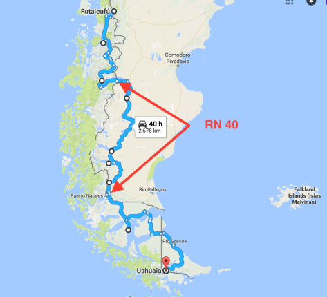
Durch den Campo de Hielo del Sur in Chile kann man nur auf Schiffen oder Fähren durch die Fjorde Patagoniens bis nach Puerto Natales oder Punta Arenas gelangen.
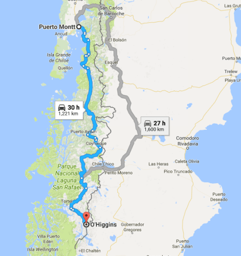
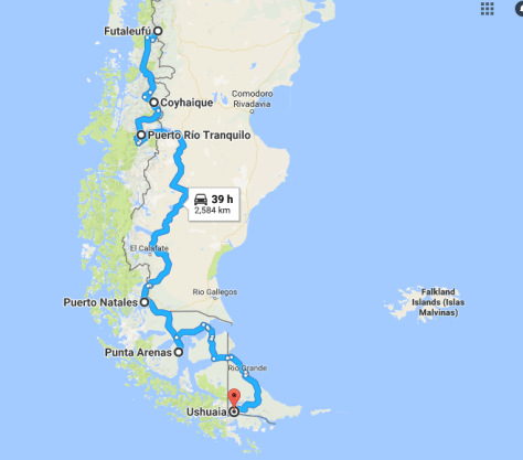
Wer mit dem Auto unterwegs ist, muss über die Ruta Nacional 40 (link folgt) in Argentinien fahren, um weiter in den Süden und später wieder nach Chile zu gelangen:
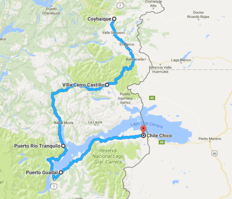
Insgesamt trennen uns jetzt noch rund 2.500 km von Ushuaia. Für die nächsten Tage haben wir uns vorgenommen, über Cerro Castillo nach Puerto Tranquilo und von dort nach Chile Chico an der Grenze zu Argentinien zu fahren.
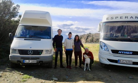
Die erste Übernachtung legen wir kurz hinter Villa Cerro Castilla ein. Auf einem Teilstück der alten Carretera Central mache wir Station und treffen dort auch ein Paar aus München, die in der anderen Richtung unterwegs sind.
Gegen Abend genießen wir die Ruhe und den Ausblick auf die nahe gelegenen Andengipfel.
Am nächsten Tag geht es weiter nach Puerto Rio Tranquilo:
Der Ort ist wirklich so ruhig wie sein Name sagt:
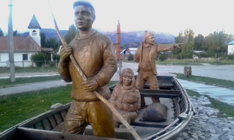
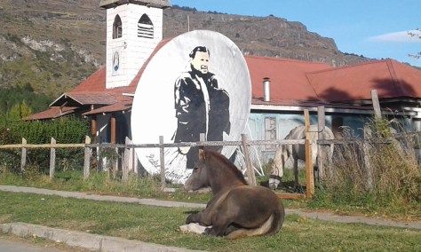
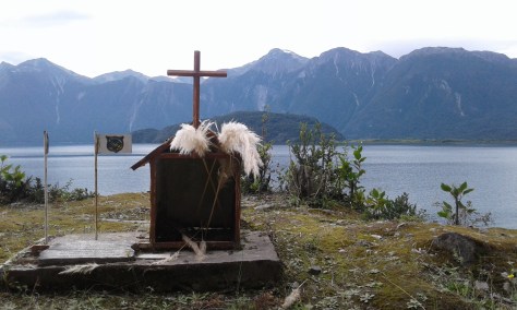
Ein hölzernes Monument macht auf die ersten Siedler aufmerksam, die vermutlich auch von der Fischerei lebten:
Es ist so ruhig hier, dass ein Pferd ein bequemes Plätzchen vor der Kapelle gefunden hat:
Heute ist es in erster Linie der Tourismus, der Puerto Rio Tranquilo am Leben erhält. Hauptsächlich sind es junge Leute, die von hier aus zu langen Trekking Touren aufbrechen.
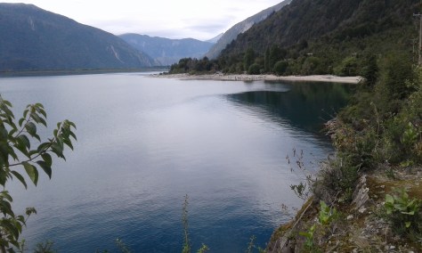
Wir stehen mit unserer Esperanza am Ufer des Lago General Carrera und selbst Shanti weiß nach ein paar Tagen nicht mehr so recht, was er hier soll – trotz des schönen Ausblicks auf See und Berge:
Wirklich beeindruckend und einmalig ist die Bootsfahrt zur nahe gelegenen Marmorkathedrale.
Danach geht es weiter bis Chile Chico an der Grenze zu Argentinien. Das sind nur noch 170 Kilometer, aber die Straße ist nicht geteert, auf der östlichen Seite des Sees teilweise einspurig und immer wieder sehr steil. Wieder einmal eine ziemliche Anstrengung für Esperanza und uns:
JW/Clea
Español
Cerca del Campo de Hielo Norte
La Patagonia es la región más amplia que hemos visitados hasta ahora.
Aquí entre Coyhaique y O’Higgins en la región de Aysén se encuentra el Campo Hielo del Norte. En este lugar se encuentra el Parque Nacional Laguna San Rafael.
Más hacia el Sur está el Campo de Hielo del Sur.
Por el Campo de Hielo del Sur en Chile se puede llegar solamente en barco o ferrys a través de los fiordos de Patagonia hasta Puerto Natales o Punta Arenas.
Quien está con el auto por ahí tiene que tomar la Ruta Nacional 40 (link folgt) en Argentina y continuar luego por el Sur para entrar nuevamente en Chile.
En total nos faltan aún 2500 km hasta Ushuaia. En los siguientes días nos hemos propuesto llegar a Chile Chico en la Frontera con Argentina. pasando por Cerro Castillo a Puerto Tranquilo y de ahí a Chile Chico.
La primera noche la casamos en Cerro Castillo. En una parte de la antigua Carretera Austral haceos un alto y ahí nos encontramos con una pareja de Múnich que va en dirección contraria a nosotros.
Por la noche disfrutamos de la tranquilidad y el panorama a los Andes cercanos.
Al día siguiente continuamos hacia Puerto Rio Tranquilo.
El Lugar es realmente tan tranquilo como su nombre lo dice.
Un monumento en madera que nos remonta a la época en que los primeros pobladores de la zona vivían de la pesca.
Es tan tranquilo acá que un caballo ha encontrado un lugar cómodo frente a la capilla.
Hoy en día Puerto Tranquilo vive más que nada del turismo. Generalmente es gente joven que emprende desde acá caminatas largas.
Estamos parados con nuestra Esperanza a la orilla del Lago General Carrera y el mismo Shanty no sabe qué hacer luego de un par de días, a pesar del encanto de lago y montañas.
Realmente impresionante resultó para nosotros el paseo hacia la Catedral de Mármol. (link).
De ahí seguimos hacia Chile Chico en la frontera con Argentina. Son solamente 170 Km pero la carretera no está asfaltada, en la parte este del lago, en una sola vía y con muchas subidas empinadas y luego bajadas. Gran esfuerzo para nuestra Esperanza su tripulación.
JW/Clea
English
At the Northern Ice Field
Patagonia is much, much bigger than any of the other regions, which we have travelled so far.
Here, between Coyhaique and O’Higgins, there is the Campo Hielo del Norte. Most of it is part of the National Park Laguna San Rafael.
Further south there is the Campo Hielo del Sur.
The only way to cross the Campo de Hielo del Sur in Chile is by boat or ferry through the fjords of Patagonia to Puerto Natales or Punta Arenas .
Those who are travelling by car, have to take the Ruta Nacional 40 (link folgt) in Argentina, to get further south and later back to Chile.
There are still about 1,600 miles to Ushuaia. In the days to come we want to drive to Cerro Castillo and Puerto Rio Tranquilo. From there to Chile Chico at the border with Argentina.
The first night after leaving Coyhaique we spend on a deserted part of the old Carretera Austral and there we meet a couple from Munich, who are travelling in their motorhome in the opposite direction.
Toward evening we enjoy the tranquility of this place and the view oft he nearby Andean peaks.
The following day we drive to Puerto Rio Tranquilo.
This place is really as quiet as its name suggests.
A wooden monument reminds of the first settlers in this remote area, who probably mainly lived on the fishing in the lake.
This village is so quiet that the horse has found a comfortable place in front of the Chapel.
Today Puerto Rio Tranquilo probably lives on tourism. It is mainly young people, who come here in order to go on long trekking tours in the beautiful mountains.
We have found a place for Esperanza and us on the beach oft he Lago General Carrera and even Shanti does not really know , what to do more after a couple of relaxing days- in spite oft he beautiful view over the lake.
Really impressive is the boat tour to the nearby Marble Cathedral.
AfterPuerto Rio Tranquilo we travel to Chile Chico near the border with Argentina. This is only about 100 miles away, but the rod is not tarred, and it is partly one lane only on the eastern side of the lake and very steep in some parts. Again a real tough ride for Esperanza and us.
Der Lago General Carrera liegt etwa in der Mitte von Patagonien und gehört zu Chile und Argentinien. Der Teil, der zu Argentinien gehört, heißt Lago Buenos Aires. Es ist der zweitgrößte See in Südamerika nach dem Titicaca-See, der zu Bolivien und Peru gehört.
Von Puerto Rio Tranquilo (in Chile) fahren wir mit einem Touristenboot zur berühmten Marmorkathedrale. Das sind Marmorhöhlen, die sich über mehrere Kilometer am Westufer des Sees erstrecken.
Die Fahrt durch die Höhlen führt durch eine märchenhafte Landschaft mit Feen, Kobolden und Sirenen, – wir hoffen, dass euch die Höhlen so gut gefallen wie uns:
JW/Clea
Español
La catedral de mármol
El Lago General Carrera está ubicado aproximadamente en el centro de Patagonia y pertenece en parte a Chile y Argentina. La parte Argentina se llama Lago Buenos Aires. Es el segundo lago de América del Sur, luego del Titicaca que colinda con Bolivia y Perú.
Desde Puerto Rio Tranquilo en la parte chilena del lago vamos en lancha a la famosa catedral de mármol. Son unas cuevas de mármol que se extienden unos kilómetros a largo de la orilla del oeste del lago.
Este viaje por las cuevas es como un viaje al país de los cuentos, hadas, sirenas … esperamos les guste también a Uds.
JW/Clea
English
The marble cathedral
The Lago General Carrera is approximately located in the center of Patagonia and belongs to Chile and Argentina. The part, which is in Argentina, is called Lago Buenos Aires. It ist the second largest lake of South America after the Lake Titicaca, which belongs to Bolivia and Peru.
From Puerto Rio Tranquilo (in Chile) we take a tour to the famous marble cathedral by boat. This is marble caves, which stretch several miles along the western bench of the lake.
The drive through the caves is like a drive through a fairy tale castle, with gremlins and sirens. We hope you like the drive through the caves like we did:
Die berühmte Carretera Austral in Chile erstreckt sich von Puerto Montt bis O´Higgins im Campo de Hielo Norte in Patagonien.
Heute ist auch die Carretera Austral auf vielen Abschnitten im nördlichen Teil geteert und mit jeder Art von Auto gut zu befahren. Es gibt aber lange Teilstrecken, die noch nicht asphaltiert sind und auch die Straßen, die von der Carretera Austral über die Anden Richtung Argentinien führen, sind nach wie vor sehr rau und für unsere Esperanza eine echte Herausforderung, z.B. die Strecke zwischen Futaleufú und der Carretera Austral:
Futaleufú ist ein kleiner Ort, gleich hinter der Grenze, wenn man aus Argentinien kommt. Hier ist eigentlich nicht viel los, aber ausgerechnet in dieser abgelegenen Siedlung in den Anden, erleben wir ein tolles Konzert der Gruppe Inti Ilimani aus Chile. Wir sind überrascht und begeistert
Da Clemen in Futaleufu ein paar Tage auf einen Arzttermin warten muss – ein Arztbesuch im staatlichen Medizinbereich ist kostenlos und effizient in Chile – beschließen wir, in der Zwischenzeit einen „Abstecher“ nach Chaitén (link) zu machen.
Auf dem Rückweg machen wir eine Wanderung durch den Parque Pumalin. Hier soll es, der Name sagt es, auch Pumas geben. Auf unseren beiden Wanderungen durch den Park sind wir keinem begegnet. Trotzdem ist es ein wunderschönes Naturerlebnis – ganz alleine – durch diesen geschützten gemäßigten Regenwald zu wandern:
Außerhalb des Parks, der von dem amerikanischen Millionär Tompkins gegründet und durch Aufkauf von über 700.000 Hektar Land ermöglicht wurde, gibt es die Termas Amarillo, die wir uns natürlich nicht entgehen lassen:
Die Strecke führt auch am Lago Yelcho vorbei. Da hier schon Herbst ist, liegen manchmal Wolken über der Region und schaffen eine düstere Atmosphäre.
Nach zwei weiteren Tagen in Futaleufú, geht es zurück zur Carretera Austral und auf dieser dann endgültig Richtung Süden. Unser Fernziel, Ushuaia auf der Insle Tierra del Fuego, ist aber immer noch weit entfernt: ca. 2600 km.
Die folgende Strecke bis Coyhaique ist weitgehend ungeteert und zum Teil im Bau. Das macht die Fahrt anstrengend und teilweise gefährlich. Vor allem die Teilstrecke bis Puyhuapi hat es in sich. Unser Auto kommt an seine Grenzen, lässt uns aber nicht im Stich.
Für die Anstrengungen der Fahrt werden wir wieder mit wunderschönen und unberührten Landschaften belohnt:
Nach einer Übernachtung in der Nähe von Puyuhapi, gegenüber der Insel Magdalena, erreichen wir am nächsten Tag Coyhaique. Das ist eine mittelgroße Stadt in Chile, in der wir uns noch einmal mit allem versorgen können, was wir für die lange Fahrt in den tiefen Süden des Kontinents benötigen:
Die Tage in Coyhaique verbringen wir auf dem Campingplatz „El Camping“, am Rande der Stadt in einer schönen Flusslandschaft. Wegen seiner strategischen Lage an der Route nach Süden (oder Norden) ist dieser Platz sehr belieb bei vielen Travellern. Hier können Landkarten, Erfahrunegen und gute Tipps ausgetauscht werden.
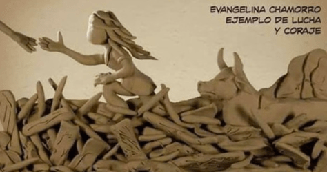
Hier erfahren wir auch von den ungeheuren Überschwemmungen und den Huaycos in Peru und hoffen, dass sich das Land wie diese Frau auf dem Plakat wieder mit ihrer Kuh aus den Schlammfluten befreien kann:
JW/Clea
Español
La conocida Carretera Austral en Chile va desde Puerto Mont hasta O´Higgins en el Campo de Hielo Norte en La Patagonia.
Hoy en día la Carretera Austral está asfaltada y es manejable con cualquier tipo de auto. Hay sin embargo largos trechos que no tienen asfalto y las carreteras de la Carretera Austral que va en dirección Argentina son fuertes y un reto para nuestra Esperanza. Por ejemplo el trecho entre Futaleufú y la Carretera Austral:
Futaleufú es un pequeño lugar detrás de la frontera, cuando se viene de Argentina. Aquí no pasa mucho, es un lugar tranquilo. Pero como son las sorpresas es justamente acá que pudimos presenciar un concierto en vivo del grupo Intiilimani de Santiago de Chile. Estamos sorprendidos y dichosos.
Como Clementina necesitaba una cita médica – que son gratis y muy eficientes en Chile – y por tanto habían días libres hicimos un salto a Chaitén. (link).
En el camino de regreso apostamos a una caminata en el Parque Pumalin. Hay pumas en esta zona, como el nombre lo indica, pero no nos tropamos con ninguno. Un paseo bellísimo en puro bosque húmedo cuidado y protegido.
Aparte de este parque que fue promovido por el millionario americano Tompkins quien pudo comprar 700.000 hectáreas preservándolas, hay también las Termas Amarillo, que lógicamente no nos las perdimos.
Esta parte va por el Lago Yelcho. Como estamos en otoño hay nubes en la zona que dan una cierta atmósfera sombria.
Después de dos días en Futaleufú retomamos la Carretera Austral dirección Sur. Nuestra última meta Ushaia, en la Isla de Tierra del Fuego está aún muy lejos, aprox. 2600 Km.
La siguiente etapa hasta Puerto Rio Tranquilo es trocha y la carretera está en construcción. Esto hace la ruta difícil y en partes peligrosa. El trecho hasta Puyuhuapi es dificilita. Esperanza llega a sus límites y no nos defrauda.
Todo este esfuerzo se ve recompensado con hermosos paisajes vírgenes de La Patagonia.
Después de una noche cerca de Puyuhapi frente de la Isla Magdalena llegamos a Coyhaique el próximo día. Coyhaique es una ciudad mediana en Chile, donde podemos abastecernos para el largo viaje al Sur del continente.
Los días en Coyhaique lo pasamos en un camping ¨El Camping¨ en las afueras de la ciudad, al borde de un río. Por su ubicación estratégica en la ruta este camping es muy visitado y punto de encuentro entre caminantes de Norte a Sur o viceversa. Es una oportunidad para intercambiar mapas y experiencias.
Es en este lugar donde nos enteramos de las inmensas lluvias y huaycos que azotaron Peru y es nuestra esperanza que tanto el país como esta mujer se libere con su vaca del barro de los huaycos.
JW/Clea
English
The famous Carretera Austral in Chile reaches from Puerto Montt to O´Higgins near the Campo de Hielo Norte in Patagonia.
Nowadays even the Carretera Austral is asphalted for big parts and can be used by all kinds of cars. But there are still many long stretches, especially the roads which lead from the Carretera Austral to the border with Argentina, which are earth roads, often corrugated and in bad shape. These parts of our trip are a real challenge for our Esperanza, for example the road between Futaleufú and the Carretera Austral:
Futaleufú is a small place, just behind the border, when you come from Argentina. There is not much going on in Futaleufú, but just in this remote location in the Andes, we can enjoy a great concert by Inti Illimani, a well now folklore music band from Santiago: We are surprised and enthusiastic:
Since Clemen has to wait for a medical appointment for a couple of days in Futalefú – which is free and very effective in Chile -, we decide to take a „side trip“ to Chaitén in the meantime.
On the way back we take a relatively short hiking tour through the Parque Pumalin. AS the name says, there are supposed to be pumas in this nature reserve, but we did not meet any wild animal on our hike. In spite of this it was a wonderful nature experience to walk totally alone through this protected piece of northern rain forest.
Outside the nature reserve, which was founded by the American millionaire Tompkins, who bought about 700,000 acres of pristine land and forest in order to protect it from further destruction, there are some hot springs, the Termas Amarillo, which we cannot miss out, of course:
The route to the south passes along the lake Yelcho. Since autumn has already arrived here, there are sometimes heavy clouds hovering over the region and create a sombre atmosphere.
After two more days in Futaleufú we drive back to the carretera austral and further south. Our final destination Ushuaia on the Grand island of tierra del fuego is still about 1,600 miles away.
The further route until Coyhaique is mainly unpaved and partly under construction. That makes the trip more difficult and even somewhat dangerous. Mainly the part before Puyuhapi has some very difficult parts to offer. Our Esperanza reaches her limits, but does not leave us in the lurch.
For the efforts of the drive we are rewarded with beautiful and pristine landscapes.
After a night near Puyuhapi opposite the Island of Magdalena we reach Coyhaique the following day. This is midsize town in Chile, where we can buy all he supplies, which we need fort he long trip tot he south of the continent.
The days in Coyhaique we spend on the campgound „El Camping“ on the outskirts of the city in a beautiful mountainous setting on a small river. This place is very popular among travellers because of its strategically great location on the route to the south. Here maps, experiences and helpful hints can be exchanged.
While we are here, we also hear from the incredible inundations and haycos, which are currently devastating Peru and we can only hope, that the country will soon recover from the disaster like this woman who raises from the mud flood, which has covered her and her cow.
Patagonien ist ein Traum. Jedenfalls für alle, die Natur und Landschaften lieben. Voller Stille, unendlich groß, überschwemmt von Blau und Grün in allen Schattierung. Reine Stadtmenschen sollten eher nach Rom, Hongkong oder New York fahren. Das ist auch interessant, – aber Patagonien hat uns gefangen genommen und den Atem verschlagen.
Es gibt Menschen, die diese Landschaften auf dem Pferderücken entdeckt und erschlossen haben (z.B. Perito Moreno) und solche, die sie zu Fuß oder mit dem Fahrrad durchqueren:
Immer wieder begegnen wir auch Rucksacktouristen, die als Hitchhiker mit wenig Geld und voller Enthusiasmus auf der Carretera Austral unterwegs sind. Einige haben wir ein Stück des Weges in unserer Esperanza mitgenommen.
Begonnen haben wir unsere Reise durch das chilenische Patagonien in Futaleufú, einem kleinen Ort, gleich hinter der Grenze, wenn man aus Argentinien kommt.
Von hier fahren wir erst einmal nach Chaitén und genießen einige Tage am schwarzen Lavastrand in der Nähe des Ortes. Von den Seehunden und sogar Walen, die hier in Strandnähe vorbeiziehen sollen, sehen wir nicht viel. Aber trotzdem fühlen wir uns sehr, sehr nahe an der Natur:
Wir spüren schon hier, am Beginn der Carretera Central, dass Patagagonien anders ist, als alles andere, was wir bisher auf unserer Fahrt gesehen haben.
JW/Clea
Español
Patagonia
Patagonia es un sueño. Silenciosa, interminable, poblada de azules y verdes. Es un sueño para todos aquellos que amamos la naturaleza y paisajes vírgenes en gran parte. La gente urbana se sentirá más cómoda seguramente en Roma, Hongkong o Nueva York. Pero la Patagonia nos ha cautivado y dejado sin aliento.
Han habido personas que han descubierto e investigado esta zona a caballo (p.e. Perito Moreno) y otros también que la han atravesado a pie o en bicicleta en estos días.
De vez en cuando nos encontramos con unos mochileros, que viajan a dedo con muy poco dinero, pero llenos de entusiasmo en la carretera austral. A algunos los hemos llevado buena parte del camino:
Empezamos nuestro viaje por la parte chilena de Patagonia en Futaleufú, una pequeña población poco después de la frontera con Argentina.
Desde allí fuimos primero al norte de nuevo, rumbo Chaitén y disfrutamos la tranquilidad en la playa negra de lava cerca de la ciudad. No vemos mucho de los lobos e inclusive ballenas, que según lo que nos contaron, deberían pasar por la costa a distancia visual. A pesar de esto nos sentimos muy cerca de la naturaleza acá.
Sentimos ya acá, donde empieza nuestro viaje en la carretera austral, que La Patagonia es diferente de todo lo que hemos visto hasta ahora en nuestro viaje.
JW/Clea
English
Patagonia is a dream. At least for those, who love nature and landscapes. Full of tranquility, infinitely big, inundated by all kinds of blue and green hews. Convinced city people should better go to Rome, Hong Kong or New York. These places are very interesting, too, – but Patagonia captivated us and left us breathless.
There are people who have discovered and explored these remote regions on horseback (i.e. Perito Moreno) and others who have crossed it on foot or by bike.
Again and again we also meet backpackers, who hitchhike on the carretera austral with little money, but full of enthusiasm. Some of them we took with us for a while in our Esperanza.
We started our trip through the Chilean part of Patagonia in Futaleufú, a small place just behind the border with Argentina.
From here we first go north again to Chaitén and enjoy a couple of days on the black lava beach near the town. Unfortunately we do not see much of the sea lions and even whales, we had been promised to idle along the beach within viewing distance. Nonetheless we feel very, very close to nature.
Here, at the beginning of our trip south on the carretera austral, we already feel, that Patagonia is different from everything, we have seen so far on our trip.